Corstopitum Social Club
Corstopitum Social Club is a building in Corbridge, Northumberland, England which is located on St Helen’s Street. Corstopitum Social Club is situated nearby to the community center Corbridge Parish Hall, as well as near The Golden Lion Public House.| Tap on a place to explore it |
Places of Interest Nearby
Highlights include Corbridge Vicar’s Pele and Church of St Andrew.
Corbridge Vicar’s Pele
Historic building

Photo: RHaworth, CC BY-SA 4.0.
Corbridge Vicar's Pele is a pele tower in the village of Corbridge, Northumberland, England. It was a three-storey defensive pele tower, with one room to each storey, built in the churchyard in 1318, and used as the vicarage for the adjacent church. Corbridge Vicar’s Pele is situated 650 feet southwest of Corstopitum Social Club.
Church of St Andrew
Church

Photo: Mike Quinn, CC BY-SA 2.0.
Church of St Andrew is situated 630 feet southwest of Corstopitum Social Club.
Corbridge Market Cross
Historic site

Photo: Victuallers, CC BY-SA 4.0.
Corbridge Market Cross is a historic site, which is situated 770 feet southwest of Corstopitum Social Club.
Places in the Area
Nearby places include Aydon and Beauclerc.
Aydon
Hamlet
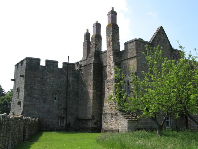
Photo: Wikimedia, CC BY-SA 2.0.
Aydon is a village and former civil parish, now in the parish of Corbridge, in Northumberland, England. It is about 2 miles northeast of Corbridge on the B6321 road.
Beauclerc
Hamlet
Beauclerc is a small village in Northumberland, England. It is situated to the west of Riding Mill, between Hexham and Newcastle upon Tyne. Beauclerc is situated 2 miles southeast of Corstopitum Social Club.
Halton
Hamlet

Photo: Mike Quinn, CC BY-SA 2.0.
Halton is a village and former civil parish, now in the parish of Whittington, in the southern part of Northumberland, England. It is situated 3 miles north of Corbridge just south of Hadrian's Wall. Halton is situated 2 miles north of Corstopitum Social Club.
Corstopitum Social Club
- Type: Building
- Address: St Helen’s Street, Corbridge, NE45 5BE
- Location: Corbridge, Northumberland, North East England, England, United Kingdom, Britain and Ireland, Europe
- View on OpenStreetMap
Latitude
54.97553° or 54° 58′ 32″ northLongitude
-2.01723° or 2° 1′ 2″ westOpen location code
9C6VXXGM+64OpenStreetMap ID
way 1211598923OpenStreetMap feature
building=yes
This page is based on OpenStreetMap, Wikidata, and Wikimedia Commons.
We’d love your help improving our open data sources. Thank you for contributing.
Satellite Map
Discover Corstopitum Social Club from above in high-definition satellite imagery.
Notable Places Nearby
Highlights include Corbridge Parish Hall and The Golden Lion Public House.
Nearby Places
Explore places such as The Amber Chinese Takeaway and Corbridge Scout Hall.
Northumberland: Must-Visit Destinations
Delve into Berwick-upon-Tweed, Lindisfarne, Alnwick, and Morpeth.
Curious Buildings to Discover
Uncover intriguing buildings from every corner of the globe.
About Mapcarta. Data © OpenStreetMap contributors and available under the Open Database License". Text is available under the CC BY-SA 4.0 license, except for photos, directions, and the map. Photo: RHaworth, CC BY 2.5.