Football Ground (15 cantons)
Football Ground (15 cantons) is a park in Plaines Wilhems District, Mauritius. Football Ground (15 cantons) is situated nearby to the church Grotto, as well as near the mosque Masjid E Munnawar.| Tap on a place to explore it |
Places of Interest Nearby
Highlights include Trou aux Cerfs and Trois Mamelles mountain.
Trou aux Cerfs
Volcano

Photo: Wikimedia, CC BY-SA 3.0 de.
Trou aux Cerfs is a dormant, crater lake, cinder cone volcano with a well-defined cone and crater. It is 605 m high and located in Curepipe, Mauritius. Trou aux Cerfs is situated 4 km east of Football Ground (15 cantons).
Trois Mamelles mountain
Peak

Photo: Georgio, CC BY-SA 3.0.
Trois Mamelles mountain is a peak, which is situated 3 km west of Football Ground (15 cantons).
Clarisse House
Building
The Clarisse House is the official residence of the Prime Minister of Mauritius at 37, Riverwalk Vacoas, Plaines Wilhems. It is frequently used for governmental conferences, summits and other official purposes, including the Prime Minister's New Year Speech. Clarisse House is situated 3 km northeast of Football Ground (15 cantons).
Places in the Area
Nearby places include Glen Park and Vacoas-Phoenix.
Glen Park
Quarter
Vacoas-Phoenix also known as French: Villes Jumelles, is a town in Mauritius, located in the Plaines Wilhems District, the eastern part also lies in the Moka District.
Vacoas-Phoenix

Photo: Wikimedia, CC BY-SA 3.0 de.
Vacoas-Phoenix also known as French: Villes Jumelles, is a town in Mauritius, located in the Plaines Wilhems District, the eastern part also lies in the Moka District.
Curepipe
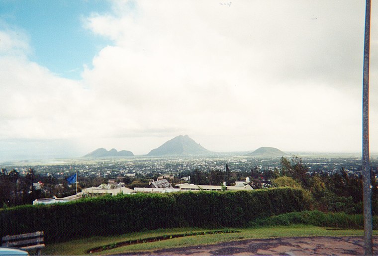
Photo: mwanasimba, CC BY-SA 2.0.
Curepipe is a sprawling town in the centre of Mauritius. At an altitude of 561 m, it marks the top of the ridge on the road between Port Louis and Vieux Grand Port, and the name may indicate that travellers rested here for long enough to smoke then clean out their clay pipes.
Football Ground (15 cantons)
- Type: Park
- Category: recreation area
- Location: Plaines Wilhems District, Mauritius, East African Islands, Africa
- View on OpenStreetMap
Latitude
-20.30763° or 20° 18′ 28″ southLongitude
57.47687° or 57° 28′ 37″ eastOpen location code
5HFVMFRG+WPOpenStreetMap ID
way 1215309411OpenStreetMap feature
leisure=park
This page is based on OpenStreetMap, Wikidata, and Wikimedia Commons.
We’d love your help improving our open data sources. Thank you for contributing.
Satellite Map
Discover Football Ground (15 cantons) from above in high-definition satellite imagery.
Notable Places Nearby
Highlights include Grotto and Masjid E Munnawar.
Nearby Places
Explore places such as K Life Self Service and Residence La Caverne (N.H.D.C).
Mauritius: Must-Visit Destinations
Delve into Port Louis, Rodrigues, Pamplemousses, and Le Morne Brabant.
Curious Parks to Discover
Uncover intriguing parks from every corner of the globe.
About Mapcarta. Data © OpenStreetMap contributors and available under the Open Database License". Text is available under the CC BY-SA 4.0 license, except for photos, directions, and the map. Photo: Wikimedia, CC0.