Aston Hills Shopping Centre
Aston Hills Shopping Centre is a building in District Council of Mount Barker, South Australia which is located on Heysen Boulevard. Aston Hills Shopping Centre is situated nearby to the health club Snap Fitness, as well as near the nature reserve Paterson Reserve.| Tap on a place to explore it |
Places of Interest Nearby
Highlights include Mount Barker and Mount Barker railway station.
Mount Barker
Peak

Photo: Mazzone, CC BY-SA 3.0.
Mount Barker is a mountain in the Mount Lofty Ranges in South Australia and namesake of the nearby town of Mount Barker. The mountain is the home to a transmission tower that services SAGRN and mobile phone transmissions throughout the area. Mount Barker is situated 4 km northeast of Aston Hills Shopping Centre.
Mount Barker railway station
Railway station
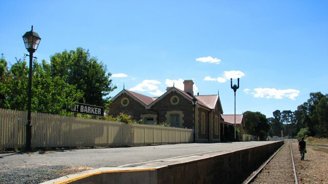
Photo: beneaththelandslide, CC BY 3.0.
Mount Barker railway station is a preserved railway station in the Adelaide Hills, South Australia, on the 1600 mm broad gauge Victor Harbor line, formerly operated by South Australian Railways and its successor, Australian National. Mount Barker railway station is situated 3½ km northwest of Aston Hills Shopping Centre.
St Francis de Sales College
School
St Francis de Sales College is a Reception to Year 12 Catholic co-educational school located in Mount Barker, South Australia. St Francis de Sales College is situated 3 km northwest of Aston Hills Shopping Centre.
Places in the Area
Nearby places include Wistow and Mount Barker.
Wistow
Hamlet

Photo: TheJosh, Public domain.
Wistow is a small town, just outside Mount Barker, on Wellington Road. It is a town formed around the intersection of Wellington Road and Long Valley Road It was home to a general store which is now a bakery/cafe with a Post Office agency, a hall and a church. Wistow is situated 3 km south of Aston Hills Shopping Centre.
Mount Barker
Town

Photo: Orderinchaos, CC BY 3.0.
Mount Barker is a city in South Australia. Located approximately 33 kilometres from the Adelaide city centre, it is home to 25,026 residents. It is the seat of the District Council of Mount Barker, the largest town in the Adelaide Hills, Part of Greater Adelaide, as well as one of the fastest-growing areas in the state. Mount Barker is situated 4 km northwest of Aston Hills Shopping Centre.
Little Hampton
Suburb

Photo: Emmanuellives, CC BY-SA 3.0.
Littlehampton is a village in the Adelaide Hills of South Australia, located on the Old Princes Highway. It is approximately 35 minutes from the Adelaide CBD via the South Eastern Freeway. Little Hampton is situated 5 km northwest of Aston Hills Shopping Centre.
Aston Hills Shopping Centre
- Type: Commercial building
- Address: 485 Heysen Boulevard
- Categories: building and office
- Location: District Council of Mount Barker, South Australia, Australia, Oceania
- View on OpenStreetMap
Latitude
-35.08713° or 35° 5′ 14″ southLongitude
138.89009° or 138° 53′ 24″ eastLevels
2Open location code
4QPWWV7R+42OpenStreetMap ID
way 1228734897OpenStreetMap feature
building=commercial
This page is based on OpenStreetMap, Wikidata, and Wikimedia Commons.
We’d love your help improving our open data sources. Thank you for contributing.
Satellite Map
Discover Aston Hills Shopping Centre from above in high-definition satellite imagery.
Notable Places Nearby
Highlights include Snap Fitness and Summit Sports Park.
Nearby Places
Explore places such as Drakes and Amcal.
South Australia: Must-Visit Destinations
Delve into Adelaide, Ikara-Flinders Ranges National Park, Dhilba Guuranda–Innes National Park, and Kangaroo Island.
Curious Places to Discover
Uncover intriguing places from every corner of the globe.
About Mapcarta. Data © OpenStreetMap contributors and available under the Open Database License". Text is available under the CC BY-SA 4.0 license, except for photos, directions, and the map. Photo: Roumpf, CC BY-SA 4.0.