Haardtrand - Mittelberg
Haardtrand - Mittelberg is a nature reserve in Wachenheim, Bad Dürkheim, Rhineland-Palatinate. Haardtrand - Mittelberg is situated nearby to the locality Hexenstein, as well as near Auf der Klärth.| Tap on a place to explore it |
Places of Interest
Highlights include Limburg Abbey and Wachtenburg.
Limburg Abbey
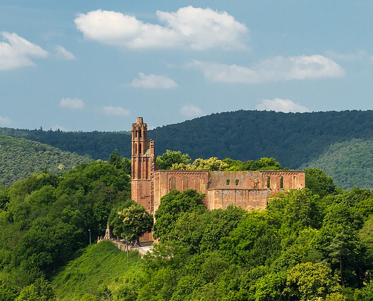
Photo: F. Riedelio, CC BY-SA 3.0 de.
Limburg Abbey is a ruined abbey near Bad Dürkheim, at the edge of the Palatinate Forest in Germany. In the 9th century, the Salian Dukes from Worms built a fortress on the Linthberg as their family seat.

Bad Dürkheim station
Railway station

Photo: Lsjm, CC BY-SA 3.0.
Bad Dürkheim station is a terminal station in Bad Dürkheim in the German state of Rhineland-Palatinate. It is on the Palatinate Northern Railway between Neustadt an der Weinstraße and Monsheim. It is classified by Deutsche Bahn as a category 5 station.
Places in the Area
Nearby places include Bad Dürkheim and Deidesheim.
Bad Dürkheim

Photo: Altera levatur, CC BY-SA 4.0.
Bad Dürkheim is a spa town in the Rhine-Neckar urban agglomeration in the Palatinate. Bad Dürkheim lies at the edge of the Palatinate Forest on the German Wine Route.
Deidesheim
Village

Photo: Jacquesverlaeken, CC BY-SA 3.0.
Deidesheim is a town in the Bad Dürkheim district in Rhineland-Palatinate, Germany with some 3,700 inhabitants. The town lies in the northwest of the Rhine-Neckar urban agglomeration and since 1973 it has been the seat of the Verbandsgemeinde of Deidesheim.
Forst an der Weinstraße
Village

Photo: Kallistratos, Public domain.
Forst an der Weinstraße is an Ortsgemeinde – a municipality belonging to a Verbandsgemeinde, a kind of collective municipality – in the Bad Dürkheim district in Rhineland-Palatinate, Germany.
Haardtrand - Mittelberg
- Type: Nature reserve
- Description: nature reserve in Rheinland-Pfalz, Germany
- Categories: Naturschutzgebiet, protected area, and recreation area
- Location: Wachenheim, Bad Dürkheim, Rhineland-Palatinate, Germany, Central Europe, Europe
- View on OpenStreetMap
Latitude
49.439° or 49° 26′ 21″ northLongitude
8.1714° or 8° 10′ 17″ eastOpen location code
8FXCC5QC+JGOpenStreetMap ID
way 1229843344OpenStreetMap feature
leisure=nature_reserveWikidata ID
Q61814639
This page is based on OpenStreetMap, Wikidata, and Wikimedia Commons.
We’d love your help improving our open data sources. Thank you for contributing.
Satellite Map
Discover Haardtrand - Mittelberg from above in high-definition satellite imagery.
In Other Languages
From French to Spanish—“Haardtrand - Mittelberg” goes by many names.
- French: “Haardtrand - Mittelberg”
- German: “Haardtrand - Mittelberg”
- German: “Naturschutzgebiet Haardtrand - Mittelberg”
- German: “NSG Haardtrand - Mittelberg”
- Spanish: “Haardtrand - Mittelberg”
Localities in the Area
Explore places such as Hexenstein and Auf der Klärth.
Notable Places Nearby
Highlights include Schlosscafe and Burgmuseum.
Rhineland-Palatinate: Must-Visit Destinations
Delve into Mainz, Trier, Koblenz, and Worms.
Curious Nature Reserves to Discover
Uncover intriguing nature reserves from every corner of the globe.
About Mapcarta. Data © OpenStreetMap contributors and available under the Open Database License". Text is available under the CC BY-SA 4.0 license, except for photos, directions, and the map. Photo: Traveler100, CC BY-SA 3.0.