Hanford Community Medical Center Helistop
Hanford Community Medical Center Helistop is a helipad in Kings County, San Joaquin Valley, California. Hanford Community Medical Center Helistop is situated nearby to the park Youth Athletic Complex, as well as near The Church of Jesus Christ of Latter Day Saints.| Tap on a place to explore it |
- Type: Helipad
- Description: airport in Kings County, California, United States of America
- Also known as: “Adventist Medical Center Hanford Heliport”
- Address: CA
Places of Interest Nearby
Highlights include Hanford station and Kings County Courthouse.
Hanford station
Railway station

Photo: David Prasad, CC BY-SA 2.0.
Hanford station is a train station in Hanford, California served by Amtrak. The station also services the larger city of Visalia, California, 20 miles to the east. Hanford station is situated 2,600 feet southeast of Hanford Community Medical Center Helistop.
Kings County Courthouse
Courthouse
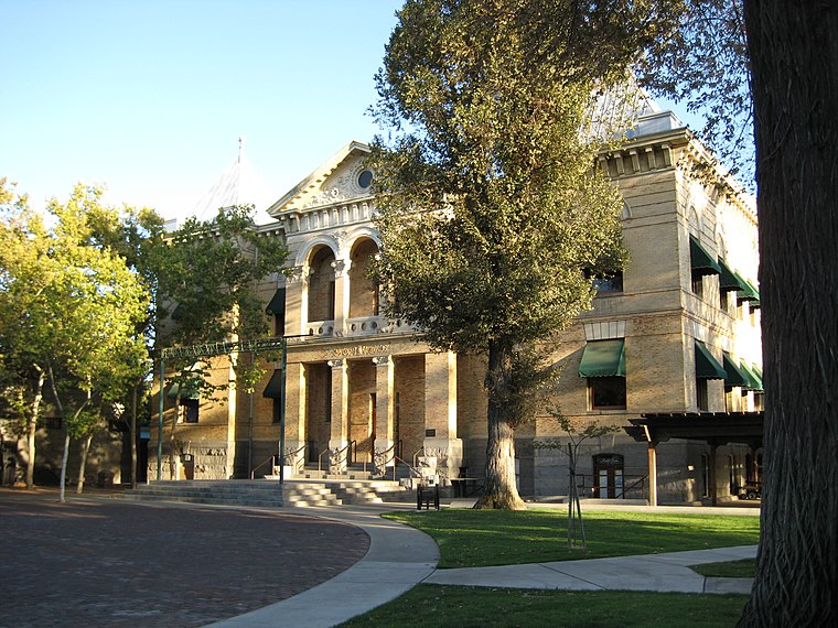
Photo: Armona, CC BY-SA 3.0.
The Kings County Courthouse was erected after Kings County, California was formed; it opened in 1896. Constructed in an eclectic mix of styles in a park in the center of Hanford, it was expanded in 1914. Kings County Courthouse is situated 3,800 feet east of Hanford Community Medical Center Helistop.
Hanford Municipal Airport
Aerodrome
Hanford Municipal Airport, formerly O18, is a mile southeast of Hanford, in Kings County, California. Most U.S. airports use the same three-letter location identifier for the FAA and IATA, but Hanford Municipal Airport is HJO to the FAA and has no IATA code. Hanford Municipal Airport is situated 2 miles southeast of Hanford Community Medical Center Helistop.
Places in the Area
Nearby places include Hanford and Home Garden.
Hanford

Photo: loboford220, CC BY-SA 3.0.
Hanford is the most populous city in and the county seat of Kings County, California, located in the San Joaquin Valley region of the greater Central Valley. The population was 57,990 at the 2020 census.
Home Garden
Hamlet
Home Garden is a census-designated place in Kings County, California, United States. The community is about 1.5 miles southeast of the city of Hanford. Home Garden is situated 2 miles southeast of Hanford Community Medical Center Helistop.
Armona
Village

Photo: Wikimedia, Public domain.
Armona is a census-designated place in Kings County, California, United States. Armona is located 3.5 miles west-southwest of Hanford, at an elevation of 239 feet. Armona is situated 3 miles west of Hanford Community Medical Center Helistop.
Hanford Community Medical Center Helistop
- Categories: airport and transportation
- Location: Kings County, San Joaquin Valley, California, United States, North America
- View on OpenStreetMap
Latitude
36.32977° or 36° 19′ 47″ northLongitude
-119.65958° or 119° 39′ 35″ westElevation
249 feet (76 metres)Open location code
858288HR+W5OpenStreetMap ID
way 1268364823OpenStreetMap feature
aeroway=helipadWikidata ID
Q49746638
This page is based on OpenStreetMap, Wikidata, and Wikimedia Commons.
We’d love your help improving our open data sources. Thank you for contributing.
Satellite Map
Discover Hanford Community Medical Center Helistop from above in high-definition satellite imagery.
In Other Languages
“Hanford Community Medical Center Helistop” goes by many names.
- Cebuano: “Hanford Community Medical Center Helistop”
Notable Places Nearby
Highlights include Adventist Medical Center Hanford and Youth Athletic Complex.
Nearby Places
Explore places such as Hanford High School West Campus and Staples.
Kings County: Must-Visit Destinations
Delve into Hanford, Lemoore, and Kettleman City.
Curious Helipads to Discover
Uncover intriguing helipads from every corner of the globe.
About Mapcarta. Data © OpenStreetMap contributors and available under the Open Database License". Text is available under the CC BY-SA 4.0 license, except for photos, directions, and the map. Photo: Wikimedia, CC0.