دافيتا لهبي
دافيتا لهبي is a hospital building in Riyadh Region, Saudi Arabia which is located on سكاكا. دافيتا لهبي is situated nearby to the marketplace مطابخ بريجيتا الألمانية, as well as near مطابخ بيت الاباء.| Tap on a place to explore it |
Places of Interest Nearby
Highlights include Faisaliyah Hotel and Kingdom Centre.
Faisaliyah Hotel
Building
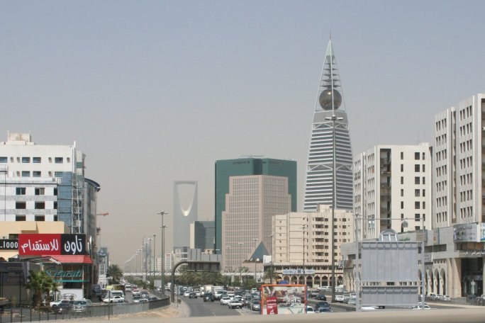
Photo: BroadArrow, CC BY-SA 3.0.
Al Faisaliah Tower is a pyramid-shaped commercial skyscraper and mixed-use complex located in the al-Olaya district of Riyadh, Saudi Arabia. The 267-metre-high office tower, the centerpiece of the Foster + Partners development, it is notable for having been… Faisaliyah Hotel is situated 1 km northeast of دافيتا لهبي.
Kingdom Centre
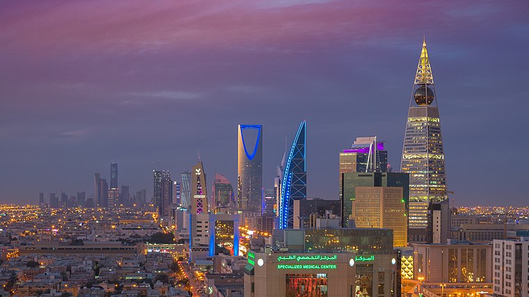
Photo: B.alotaby, CC BY-SA 4.0.
Kingdom Centre, formerly Kingdom Tower, is a 41-story, 302.3 m skyscraper in the al-Olaya district of Riyadh, Saudi Arabia. When completed in 2002, it overtook the 267-meter Faisaliah Tower as the tallest tower in Saudi Arabia. Kingdom Centre is situated 3 km north of دافيتا لهبي.
Bank Al Bilad
Metro station

Photo: الشيخ هيثم بن علي الدخين, CC BY-SA 4.0.
Bank Al Bilad is a metro station, which is situated 1½ km northeast of دافيتا لهبي.
Places in the Area
Nearby places include Diplomatic Quarter and Riyadh.
Diplomatic Quarter
Neighborhood
The Diplomatic Quarter, also known by its Arabic name as-Safarat, is a diplomatic enclave and an affluent residential district in northwestern Riyadh, Saudi Arabia, situated in close proximity to Irqah. Diplomatic Quarter is situated 5 km west of دافيتا لهبي.
Riyadh
 Riyadh is the capital of Saudi Arabia, slightly east of the center of the country in the heart of the Tuwaig escarpment.
KAFD
Neighborhood

Photo: Ahmed, CC BY-SA 4.0.
King Abdullah Financial District is a mixed-use financial district located in the al-Aqeeq neighbourhood of Riyadh, Saudi Arabia Managed by the King Abdullah Financial District Development and Management Company, a wholly owned subsidiary of the Kingdom's Public Investment Fund. KAFD is situated 10 km north of دافيتا لهبي.
دافيتا لهبي
- Type: Hospital building
- Address: سكاكا, الرياض
- Categories: building and health care
- Location: Riyadh Region, Saudi Arabia, Middle East, Asia
- View on OpenStreetMap
Latitude
24.68366° or 24° 41′ 1″ northLongitude
46.67675° or 46° 40′ 36″ eastOpen location code
7HP8MMMG+FPOpenStreetMap ID
way 1301258423OpenStreetMap feature
building=hospital
This page is based on OpenStreetMap, Wikidata, and Wikimedia Commons.
We’d love your help improving our open data sources. Thank you for contributing.
Satellite Map
Discover دافيتا لهبي from above in high-definition satellite imagery.
Notable Places Nearby
Highlights include مطابخ بريجيتا الألمانية and مطابخ بيت الاباء.
Nearby Places
Explore places such as شقق درر رامه للشقق and صالون دونا للتزيين النسائي.
Saudi Arabia: Must-Visit Destinations
Delve into Mecca, Riyadh, Medina, and Jeddah.
Curious Places to Discover
Uncover intriguing places from every corner of the globe.
About Mapcarta. Data © OpenStreetMap contributors and available under the Open Database License". Text is available under the CC BY-SA 4.0 license, except for photos, directions, and the map. Photo: Mardetanha, CC BY-SA 3.0.