Filipino United Church of Christ
Filipino United Church of Christ is a church in Honolulu County, Hawaii which is located on Hiapo Street. Filipino United Church of Christ is situated nearby to Inspire church, as well as near the health club UFC GYM.| Tap on a place to explore it |
Places of Interest Nearby
Highlights include Hans L’Orange Field and Wakamiya Inari Shrine.
Hans L’Orange Field
Sports venue
Hans L'Orange Field is a stadium in Waipahu, Hawai'i, United States. It is primarily used for baseball, and is the home field of Hawaii Pacific University's men's baseball team, the Sharks, since 2016. It has a capacity of 2,100. Hans L’Orange Field is situated 4,200 feet southwest of Filipino United Church of Christ.
Wakamiya Inari Shrine
Shinto shrine
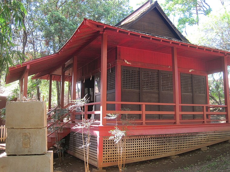
Photo: Joel Bradshaw, Public domain.
Wakamiya Inari Shrine at Waipahu Cultural Garden in Waipahu, Hawaiʻi, is the last surviving example of Inari Shrine architecture on Oʻahu. Unlike most Shinto shrines, which are unpainted, those dedicated to the fox deity Inari, the god of the harvest, are painted bright red. Wakamiya Inari Shrine is situated 1¼ miles southwest of Filipino United Church of Christ.
Leeward Community College
Metro station

Photo: RickyCourtney, CC BY-SA 4.0.
Hālaulani station is a Skyline metro station in Pearl City, Hawaiʻi, serving the Leeward Community College campus. The station is located alongside Ala ʻIke Street and can be accessed from a building on the college campus, with passengers using a tunnel to travel under Ala ʻIke Street and the eastbound track. Leeward Community College is situated 1 mile east of Filipino United Church of Christ.
Places in the Area
Nearby places include Crestview and Central Oahu.
Crestview
Suburb
Waipiʻo is a census-designated place located on the island of Oʻahu in the City & County of Honolulu, Hawaii, United States. In Hawaiian, wai piʻo means "curved water".
Central Oahu
 Central Oahu is probably the least interesting of the Oahu's regions, but is a good place to stock up on supplies if you're staying on the North Shore.
Village Park
Suburb
Village Park was a census-designated place in Honolulu County, Hawaiʻi, United States. The population was 9,625 at the 2000 census. For the 2010 census, it was replaced by the Royal Kunia CDP. Village Park is situated 1½ miles west of Filipino United Church of Christ.
Filipino United Church of Christ
- Type: Church
- Address: 94-1336 Hiapo Street, Waipahu, HI 96797
- Categories: building and religion
- Location: Honolulu County, Hawaii, United States, North America
- View on OpenStreetMap
Latitude
21.39861° or 21° 23′ 55″ northLongitude
-157.99973° or 157° 59′ 59″ westOpen location code
73H492X2+C4OpenStreetMap ID
way 1316551607OpenStreetMap feature
building=church
This page is based on OpenStreetMap, Wikidata, and Wikimedia Commons.
We’d love your help improving our open data sources. Thank you for contributing.
Satellite Map
Discover Filipino United Church of Christ from above in high-definition satellite imagery.
Notable Places Nearby
Highlights include Inspire church and UFC GYM.
Nearby Places
Explore places such as Golf Club Estates and Lumiaina Street + Pulelo Street.
Hawaii: Must-Visit Destinations
Delve into Honolulu, Kauai, Hilo, and Molokai.
Curious Churches to Discover
Uncover intriguing churches from every corner of the globe.
About Mapcarta. Data © OpenStreetMap contributors and available under the Open Database License". Text is available under the CC BY-SA 4.0 license, except for photos, directions, and the map. Photo: Outdoorhighadventure, CC BY 3.0.