Telus Quebec Rimouski
Telus Quebec Rimouski is a building in Rimouski, Bas-Saint-Laurent, Quebec which is located on Boulevard de la Rivière. Telus Quebec Rimouski is situated nearby to the park Parc du centre communautaire Sainte-Odile, as well as near the islet Les Petits Îlets.| Tap on a place to explore it |
Places of Interest Nearby
Highlights include Colisée Financière Sun Life and Rimouski station.
Colisée Financière Sun Life
Stadium

Photo: JF Lepage, CC BY-SA 3.0.
The Colisée Financière Sun Life is a 4,030-seat multi-purpose arena in Rimouski, Quebec, Canada, built in 1966. It is home to the Rimouski Océanic ice hockey team, and the arena hosted the 2009 Memorial Cup. Colisée Financière Sun Life is situated 2 km northeast of Telus Quebec Rimouski.
Rimouski station
Railway station

Photo: Wikimedia, CC BY-SA 3.0.
Rimouski station is a Via Rail station in Rimouski, Quebec, Canada. It is located on Rue de l'Évèché, is staffed and wheelchair-accessible. Rimouski is served by Via Rail's Ocean and was served by Montreal–Gaspé train until the latter was suspended in 2013. Rimouski station is situated 2½ km northeast of Telus Quebec Rimouski.
Maison Joseph-Gauvreau
Retail building
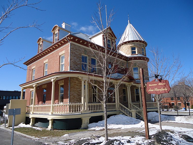
Photo: JF Lepage, CC BY-SA 3.0.
Maison Joseph-Gauvreau is a heritage building located in Rimouski, in the Bas-Saint-Laurent region of Quebec. Constructed in 1906 and 1907 for Dr. Joseph Gauvreau, this eclectic-style bourgeois home served as his principal residence, as well as housing his medical practice and hydrotherapy clinic, whose fame spread throughout Quebec. Maison Joseph-Gauvreau is situated 2 km northeast of Telus Quebec Rimouski.
Places in the Area
Nearby places include Saint-Anaclet-de-Lessard.
Saint-Anaclet-de-Lessard
Village

Photo: Mathieu19, CC BY-SA 4.0.
Saint-Anaclet-de-Lessard is a parish municipality in the Canadian province of Quebec, located in the Rimouski-Neigette Regional County Municipality. Saint-Anaclet-de-Lessard is situated 10 km northeast of Telus Quebec Rimouski.
Telus Quebec Rimouski
- Type: Building
- Address: 400 Boulevard de la Rivière, Rimouski, Quebec
- Location: Rimouski, Bas-Saint-Laurent, Southeastern Quebec, Quebec, Canada, North America
- View on OpenStreetMap
Latitude
48.43344° or 48° 26′ 0″ northLongitude
-68.54109° or 68° 32′ 28″ westOperator
TELUSOpen location code
87WHCFM5+9HOpenStreetMap ID
way 1330204578OpenStreetMap feature
building=service
This page is based on OpenStreetMap, Wikidata, and Wikimedia Commons.
We’d love your help improving our open data sources. Thank you for contributing.
Satellite Map
Discover Telus Quebec Rimouski from above in high-definition satellite imagery.
Notable Places Nearby
Highlights include Parc du centre communautaire Sainte-Odile and Les Petits Îlets.
Nearby Places
Explore places such as Tessier (Friperie de l’Est - Centre de tri) and Cantine Ste-Odile.
Bas-Saint-Laurent: Must-Visit Destinations
Delve into Rivière-du-Loup, Saint-Louis-du-Ha! Ha!, and Trois-Pistoles.
Curious Buildings to Discover
Uncover intriguing buildings from every corner of the globe.
About Mapcarta. Data © OpenStreetMap contributors and available under the Open Database License". Text is available under the CC BY-SA 4.0 license, except for photos, directions, and the map. Photo: FRED, CC BY-SA 3.0.