Zone Industrielle Chanteloup
Zone Industrielle Chanteloup is in Sevran, Arrondissement of Le Raincy, Île-de-France. Zone Industrielle Chanteloup is situated nearby to Rougemont – Chanteloup railway station, as well as near Canal de l’Ourcq.| Tap on a place to explore it |
Places of Interest Nearby
Highlights include Rougemont – Chanteloup railway station and Aulnay-sous-Bois station.
Rougemont – Chanteloup railway station
Railway station

Photo: Clicsouris, CC BY-SA 3.0.
Rougemont – Chanteloup is a railway station located on the Île-de-France tramway Line 4 in the commune of Sevran. The station is situated between the neighborhood of Rougemont in Sevran and the industrial park of Chanteloup in Aulnay-sous-Bois. Rougemont – Chanteloup railway station is situated 340 metres east of Zone Industrielle Chanteloup.
Aulnay-sous-Bois station
Railway station
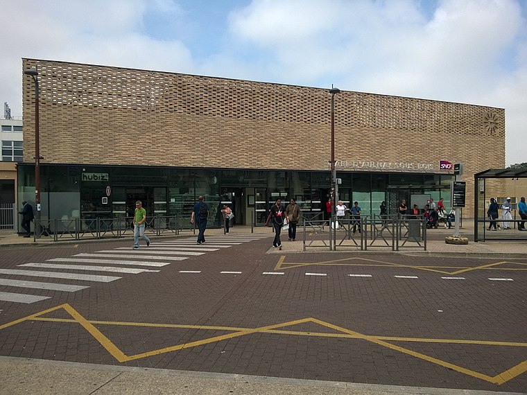
Photo: Skililipappa, CC BY-SA 4.0.
Aulnay-sous-Bois station is the major railway station in the town of Aulnay-sous-Bois, in the department of Seine-Saint-Denis). It is on the RER B and the Transilien K lines. The station is also the terminus for tramway T4. Aulnay-sous-Bois station is situated 1¼ km west of Zone Industrielle Chanteloup.
Église Sainte-Élisabeth de Freinville
Church
 Église Sainte-Élisabeth de Freinville is a church, which is situated 670 metres southeast of Zone Industrielle Chanteloup.
Places in the Area
Nearby places include Aulnay-sous-Bois and Sevran.
Aulnay-sous-Bois
Town

Photo: Suaudeau, CC BY-SA 3.0.
Aulnay-sous-Bois is a commune in the Seine-Saint-Denis department in the Île-de-France region in the north-eastern suburbs of Paris, France. It is located 13.9 km from the Kilometre zero of France.
Sevran
Town

Photo: Chabe01, CC BY-SA 4.0.
Sevran is a commune in the French department of Seine-Saint-Denis, northeastern suburbs of Paris, Île-de-France. It is located 16.2 km from the center of Paris.
Livry-Gargan
Town

Photo: Chabe01, CC BY-SA 4.0.
Livry-Gargan is a commune in the northeastern suburbs of Paris, France. It is located 15.6 km from the center of Paris.
Zone Industrielle Chanteloup
- Type: Industry
- Location: Sevran, Arrondissement of Le Raincy, Seine-Saint-Denis, Île-de-France, France, Europe
- View on OpenStreetMap
Latitude
48.92988° or 48° 55′ 48″ northLongitude
2.51073° or 2° 30′ 39″ eastOpen location code
8FW4WGH6+X7OpenStreetMap ID
way 134018845OpenStreetMap feature
landuse=industrial
This page is based on OpenStreetMap, Wikidata, and Wikimedia Commons.
We’d love your help improving our open data sources. Thank you for contributing.
Satellite Map
Discover Zone Industrielle Chanteloup from above in high-definition satellite imagery.
Notable Places Nearby
Highlights include Canal de l’Ourcq and Parc Bigottini.
Nearby Places
Explore places such as Intermarché and Chanteloup.
Île-de-France: Must-Visit Destinations
Delve into Paris, Versailles, Boulogne-Billancourt, and Paris Charles de Gaulle Airport.
Curious Places to Discover
Uncover intriguing places from every corner of the globe.
About Mapcarta. Data © OpenStreetMap contributors and available under the Open Database License". Text is available under the CC BY-SA 4.0 license, except for photos, directions, and the map. Photo: Romain D C, CC BY-SA 3.0.