Corrib Court
Corrib Court is an apartment building in Enfield, Greater London, England which is located on Crothall Close. Corrib Court is situated nearby to the community center Burford Hall, as well as near Palmers Green United Reformed Church.| Tap on a place to explore it |
Places of Interest Nearby
Highlights include Palmers Green United Reformed Church and Palmers Green railway station.
Palmers Green United Reformed Church
Church

Photo: Philafrenzy, CC BY-SA 4.0.
Palmers Green United Reformed Church is a united reformed church in Fox Lane, Palmers Green, north London. Palmers Green United Reformed Church is situated 700 feet southeast of Corrib Court.
Palmers Green railway station
Railway station
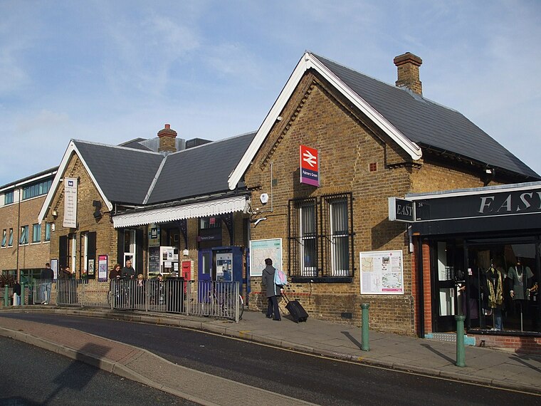
Photo: Sunil060902, CC BY-SA 3.0.
Palmers Green railway station, in Aldermans Hill, is a train station in the London Borough of Enfield in north London, located within Travelcard Zone 4. Palmers Green railway station is situated 2,100 feet south of Corrib Court.
Intimate Theatre
Theater building

Photo: John Salmon, CC BY-SA 2.0.
The Intimate Theatre was a theatre on Green Lanes in Palmers Green, London from 1937 to 2019, and is the name commonly used for St. Monica's Church Hall. Intimate Theatre is situated 2,100 feet east of Corrib Court.
Places in the Area
Nearby places include Palmers Green and Winchmore Hill.
Palmers Green
Suburb

Photo: John Salmon, CC BY-SA 2.0.
Palmers Green is a suburban area and electoral ward in north London, England, within the London Borough of Enfield. It is located within the N13 postcode district, around 8 miles north of Charing Cross.
Winchmore Hill
Quarter
Winchmore Hill is a suburb and electoral ward in the London Borough of Enfield, north London, England, in the N21 postal district. The Winchmore Hill conservation area serves as the focal point of the district.
Southgate
Suburb

Photo: Londoneye, CC BY-SA 3.0.
Southgate is a suburban area of north London, England, in the London Borough of Enfield, 8 miles north of Charing Cross.
Corrib Court
- Type: Apartment building
- Address: 49 Crothall Close, London, N13 4BG
- Categories: building and residential building
- Location: Enfield, Greater London, England, United Kingdom, Britain and Ireland, Europe
- View on OpenStreetMap
Latitude
51.62419° or 51° 37′ 27″ northLongitude
-0.11205° or 0° 6′ 43″ westOpen location code
9C3XJVFQ+M5OpenStreetMap ID
way 1340389880OpenStreetMap feature
building=apartments
This page is based on OpenStreetMap, Wikidata, and Wikimedia Commons.
We’d love your help improving our open data sources. Thank you for contributing.
Satellite Map
Discover Corrib Court from above in high-definition satellite imagery.
Notable Places Nearby
Highlights include Burford Hall and Conway Recreation Ground.
Nearby Places
Explore places such as Menlow Lodge and Everard Court.
England: Must-Visit Destinations
Delve into London, Manchester, Sheffield, and Leeds.
Curious Apartment Buildings to Discover
Uncover intriguing apartment buildings from every corner of the globe.
About Mapcarta. Data © OpenStreetMap contributors and available under the Open Database License". Text is available under the CC BY-SA 4.0 license, except for photos, directions, and the map. Photo: sidibousaid, CC BY 2.0.