Tendance des Marques
Tendance des Marques is a clothing store in Vitry-sur-Seine, Arrondissement of L’Haÿ-les-Roses, Île-de-France. Tendance des Marques is situated nearby to the hospital Hôpital privé de Vitry - Site Pasteur, as well as near the park Square Perrot.| Tap on a place to explore it |
Places of Interest Nearby
Highlights include Exploradôme and Youri Gagarine - Commune de Paris.
Exploradôme
Museum
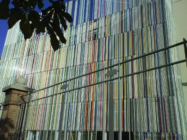
Photo: Wikimedia, CC BY-SA 4.0.
The Exploradôme is a science museum located in Vitry-sur-Seine in the Val-de-Marne, France. It was founded by Goéry Delacôte. It is open daily; an admission fee is charged. Exploradôme is situated 1 km north of Tendance des Marques.
Youri Gagarine - Commune de Paris
Bike rental

Photo: Chabe01, CC BY-SA 4.0.
Youri Gagarine - Commune de Paris is a bike rental, which is situated 360 metres southeast of Tendance des Marques.
Église Saint-Germain de Vitry-sur-Seine
Church

Photo: Chabe01, CC BY-SA 4.0.
Église Saint-Germain de Vitry-sur-Seine is a church, which is situated 720 metres north of Tendance des Marques.
Places in the Area
Nearby places include Villejuif and Thiais.
Villejuif
Town
Photo: Chabe01, CC BY-SA 4.0.
Villejuif is a commune in the southern suburbs of Paris, France. It is located 7 km from the centre of Paris.
Thiais
Town

Photo: besopha, CC BY-SA 2.0.
Thiais is a commune in the southern suburbs of Paris, France. It is located 10.3 km from the center of Paris. The name Thiais comes from Medieval Latin Theodasium or Theodaxium, meaning "estate of Theodasius", a Gallo-Roman landowner.
Choisy-le-Roi
Town

Photo: 1quidam, CC BY-SA 3.0.
Choisy-le-Roi is a commune in the Val-de-Marne department, in the southeastern suburbs of Paris, Île-de-France. Choisy-le-Roi is situated 3 km southeast of Tendance des Marques.
Tendance des Marques
- Type: Clothing store
- Category: shop
- Location: Vitry-sur-Seine, Arrondissement of L’Haÿ-les-Roses, Val-de-Marne, Île-de-France, France, Europe
- View on OpenStreetMap
Latitude
48.78534° or 48° 47′ 7″ northLongitude
2.3917° or 2° 23′ 30″ eastOpen location code
8FW4Q9PR+4MOpenStreetMap ID
way 1350357252OpenStreetMap feature
shop=clothes
This page is based on OpenStreetMap, Wikidata, and Wikimedia Commons.
We’d love your help improving our open data sources. Thank you for contributing.
Satellite Map
Discover Tendance des Marques from above in high-definition satellite imagery.
Notable Places Nearby
Highlights include Hôpital privé de Vitry - Site Pasteur and Square Perrot.
Nearby Places
Explore places such as Mike Clive Studios and Bistro-Alain.
Île-de-France: Must-Visit Destinations
Delve into Paris, Versailles, Boulogne-Billancourt, and Paris Charles de Gaulle Airport.
Curious Clothing Stores to Discover
Uncover intriguing clothing stores from every corner of the globe.
About Mapcarta. Data © OpenStreetMap contributors and available under the Open Database License". Text is available under the CC BY-SA 4.0 license, except for photos, directions, and the map. Photo: Guillaume Baviere, CC BY 2.0.