Fuel Site 018
Fuel Site 018 is a building in Philadelphia, Philadelphia Region, Pennsylvania which is located on Richmond Street. Fuel Site 018 is situated nearby to the recreation area Bridesburg Father’s Club Fields, as well as near Grace Episcopal Church.| Tap on a place to explore it |
Places of Interest Nearby
Highlights include Betsy Ross Bridge and St. Adalbert in Philadelphia.
Betsy Ross Bridge
Bridge

Photo: Dough4872, CC BY-SA 4.0.
The Betsy Ross Bridge is a continuous steel truss bridge spanning the Delaware River from Philadelphia, Pennsylvania to Pennsauken, New Jersey. It was built from 1969 to 1974, and opened in April 1976, during the American Bicentennial Year. Betsy Ross Bridge is situated 1 mile southeast of Fuel Site 018.
St. Adalbert in Philadelphia
Church

Photo: Wikited, CC BY-SA 3.0.
The Church of St. Adalbert in Philadelphia, Pennsylvania, is a Roman Catholic church, constructed in the Polish Cathedral style. It is located in the Port Richmond neighborhood at 2645 E. Allegheny Avenue. St. Adalbert in Philadelphia is situated 1 mile southwest of Fuel Site 018.
First Presbyterian Church of Bridesburg
Church

Photo: Wikimedia, Public domain.
First Presbyterian Church of Bridesburg is situated 1¼ miles northeast of Fuel Site 018.
Places in the Area
Nearby places include Port Richmond and Bridesburg.
Port Richmond
Neighborhood

Photo: Wikited, CC BY-SA 3.0.
Port Richmond is a neighborhood in the River Wards section of Philadelphia, Pennsylvania, United States. It is notable for its large Polish immigrant and Polish American community, and it has been known as the Little Poland of Philadelphia.
Bridesburg
Neighborhood
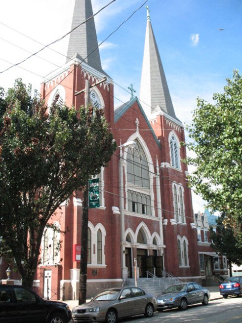
Photo: Gapone1979, CC BY-SA 3.0.
Bridesburg is the northernmost neighborhood in the River Wards section of Philadelphia, Pennsylvania, United States. A mostly working-class neighborhood, Bridgesburg is an historically German and Irish community, with a significant community of Polish immigrants who arrived mostly in the early- to mid-twentieth century.
Juniata
Neighborhood

Photo: Curtbookworm90, CC BY-SA 3.0.
Juniata is a working class neighborhood in Northeast Philadelphia, which is a section of the city of Philadelphia, Pennsylvania, United States. Juniata is located south of the Juniata Golf Club in Tacony Creek Park. Juniata is situated 2 miles northwest of Fuel Site 018.
Fuel Site 018
- Type: Building
- Address: 3899 Richmond Street, Philadelphia, PA
- Location: Philadelphia, Philadelphia, Philadelphia Region, Pennsylvania, Mid-Atlantic, United States, North America
- View on OpenStreetMap
Latitude
39.99107° or 39° 59′ 28″ northLongitude
-75.08403° or 75° 5′ 3″ westHeight
18 feet (5.5 metres)Open location code
87F6XWR8+C9OpenStreetMap ID
way 1354788146OpenStreetMap feature
building=yes
This page is based on OpenStreetMap, Wikidata, and Wikimedia Commons.
We’d love your help improving our open data sources. Thank you for contributing.
Satellite Map
Discover Fuel Site 018 from above in high-definition satellite imagery.
Notable Places Nearby
Highlights include Bridesburg Father’s Club Fields and Grace Episcopal Church.
Nearby Places
Explore places such as Garage 415 and Northeast Transfer Station.
Philadelphia: Must-Visit Destinations
Delve into Philadelphia International Airport, Old City, West Philadelphia, and Center City West.
Curious Buildings to Discover
Uncover intriguing buildings from every corner of the globe.
About Mapcarta. Data © OpenStreetMap contributors and available under the Open Database License". Text is available under the CC BY-SA 4.0 license, except for photos, directions, and the map. Photo: Dave Z, CC BY 2.0.