Ecole Nationale De Mare Rouge
Ecole Nationale De Mare Rouge is a school building in Port-de-Paix Arrondissement, Nord-Ouest. Ecole Nationale De Mare Rouge is situated nearby to the hospital DISPENSAIRE DE MARE ROUGE.| Tap on a place to explore it |
Places in the Area
Nearby places include Tortuga.
Tortuga
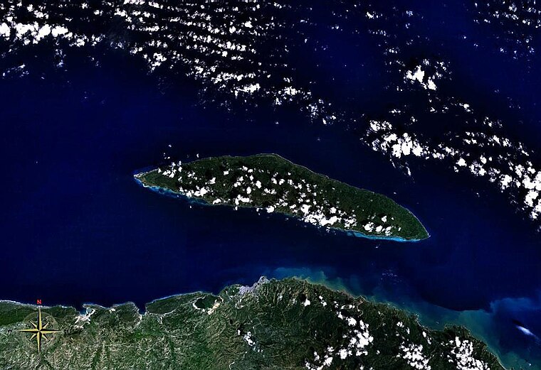
Photo: Wikimedia, Public domain.
Tortuga Island is a West Indian island that forms part of Haiti, off the northwest coast of Hispaniola. It constitutes the commune of Île de la Tortue in the Port-de-Paix arrondissement of the Nord-Ouest department of Haiti.
Ecole Nationale De Mare Rouge
- Type: School building
- Categories: building and education
- Location: Port-de-Paix Arrondissement, Nord-Ouest, Haiti, Caribbean, North America
- View on OpenStreetMap
Latitude
20.03151° or 20° 1′ 53″ northLongitude
-72.78715° or 72° 47′ 14″ westOpen location code
77G926J7+J4OpenStreetMap ID
way 1358646374OpenStreetMap feature
building=school
This page is based on OpenStreetMap, Wikidata, and Wikimedia Commons.
We’d love your help improving our open data sources. Thank you for contributing.
Satellite Map
Discover Ecole Nationale De Mare Rouge from above in high-definition satellite imagery.
Notable Places Nearby
Highlights include DISPENSAIRE DE MARE ROUGE and Possible chantier naval.
Nearby Places
Explore places such as Ecole Nationale De Mare Rouge and Ecole Nationale De Mare Rouge.
Haiti: Must-Visit Destinations
Delve into Port-au-Prince, Cap-Haïtien, Tortuga, and Jacmel.
Curious Schools to Discover
Uncover intriguing schools from every corner of the globe.
About Mapcarta. Data © OpenStreetMap contributors and available under the Open Database License". Text is available under the CC BY-SA 4.0 license, except for photos, directions, and the map. Photo: Wikimedia, CC0.