Haardtrand - Am Hinterberg
Haardtrand - Am Hinterberg is a nature reserve in Bad Dürkheim, Palatinate, Rhineland-Palatinate. Haardtrand - Am Hinterberg is situated nearby to the suburb Grethen, as well as near the locality Kastaniendelle.| Tap on a place to explore it |
Places of Interest
Highlights include Limburg Abbey and Kriemhildenstuhl.
Limburg Abbey
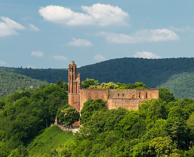
Photo: F. Riedelio, CC BY-SA 3.0 de.
Limburg Abbey is a ruined abbey near Bad Dürkheim, at the edge of the Palatinate Forest in Germany. In the 9th century, the Salian Dukes from Worms built a fortress on the Linthberg as their family seat.
Kriemhildenstuhl
Protected area

Photo: Maik Riede, CC BY-SA 4.0.
The Kriemhildenstuhl, more rarely Krimhildenstuhl, in the forests around the Palatine county town of Bad Dürkheim in the German state of Rhineland-Palatinate, is an old Roman quarry, which was worked by the 22nd Legion of the Roman Army, who were stationed in Mogontiacum around 200 A.
Hardenburg

Photo: Muck50, CC BY-SA 4.0.
The Hardenburg on the eastern edge of the Palatinate Forest near the Rhineland-Palatinate town of Bad Dürkheim is even as a ruin one of the mightiest castles of Palatinate. It was the residence of the Counts of Leiningen, who in 1725 moved to Schloss Dürkheim.
Places in the Area
Nearby places include Wachenheim and Forst an der Weinstraße.
Wachenheim
Village

Photo: Alektryo, CC BY-SA 4.0.
Wachenheim an der Weinstraße is a small town in the Bad Dürkheim district in Rhineland-Palatinate, Germany, roughly 1 km south of Bad Dürkheim and 20 km west of Ludwigshafen.
Forst an der Weinstraße
Village

Photo: Kallistratos, Public domain.
Forst an der Weinstraße is an Ortsgemeinde – a municipality belonging to a Verbandsgemeinde, a kind of collective municipality – in the Bad Dürkheim district in Rhineland-Palatinate, Germany.
Friedelsheim
Village

Photo: Immanuel Giel, CC BY-SA 3.0.
Friedelsheim is an Ortsgemeinde – a municipality belonging to a Verbandsgemeinde, a kind of collective municipality – in the Bad Dürkheim district in Rhineland-Palatinate, Germany.
Haardtrand - Am Hinterberg
- Type: Nature reserve
- Category: recreation area
- Location: Bad Dürkheim, Bad Dürkheim, Palatinate, Rhineland-Palatinate, Germany, Central Europe, Europe
- View on OpenStreetMap
Latitude
49.4592° or 49° 27′ 33″ northLongitude
8.1563° or 8° 9′ 23″ eastOpen location code
8FXCF554+MGOpenStreetMap ID
way 1366303726OpenStreetMap feature
leisure=nature_reserve
This page is based on OpenStreetMap, Wikidata, and Wikimedia Commons.
We’d love your help improving our open data sources. Thank you for contributing.
Satellite Map
Discover Haardtrand - Am Hinterberg from above in high-definition satellite imagery.
Localities in the Area
Explore places such as Grethen and Kastaniendelle.
Notable Places Nearby
Highlights include Kaiser Wilhelms Höhe and Kaiser-Wilhelm-Höhe.
Palatinate: Must-Visit Destinations
Delve into Ludwigshafen, Speyer, Kaiserslautern, and Pirmasens.
Curious Nature Reserves to Discover
Uncover intriguing nature reserves from every corner of the globe.
About Mapcarta. Data © OpenStreetMap contributors and available under the Open Database License". Text is available under the CC BY-SA 4.0 license, except for photos, directions, and the map. Photo: Wikimedia, CC0.