Hinxworth Place
Hinxworth Place is a medieval manor house near Hinxworth, Hertfordshire, England. Formerly the Manor of Pulters, building was started c. 1390. The construction is of clunch with loose flint filling cavities in the lower part of the walls.| Tap on a place to explore it |
Places of Interest Nearby
Highlights include St Mary Magdalene’s Church, Caldecote and Ashwell Quarry and Quarry Springs.
St Mary Magdalene’s Church, Caldecote
Church

Photo: John Salmon, CC BY-SA 2.0.
St Mary Magdalene's Church is a redundant Anglican church standing in the deserted medieval village of Caldecote, Hertfordshire, England. It is recorded in the National Heritage List for England as a designated Grade II* listed building, and is under the care of the Friends of Friendless Churches. St Mary Magdalene’s Church, Caldecote is situated 3,900 feet south of Hinxworth Place.
Ashwell Quarry and Quarry Springs
Nature reserve
Ashwell Quarry and Quarry Springs is a three hectare nature reserve managed by the Herts and Middlesex Wildlife Trust near Ashwell in Hertfordshire. Ashwell Quarry is owned by a local farmer, and Quarry Springs by Hertfordshire County Council.
Arbury Banks
Archaeological site

Photo: A2-33, CC BY-SA 3.0.
Arbury Banks is a hill fort southwest of Ashwell, Hertfordshire, England. It was probably first constructed during the late Bronze Age, 1000-700 BC. Standing at 90 m above sea level, it is one of a line of six similar hill forts along the northern Chilterns that includes Wilbury Hill Camp southwest of Letchworth. Arbury Banks is situated 1½ miles southeast of Hinxworth Place.
Places in the Area
Nearby places include Hinxworth and Caldecote.
Hinxworth
Village
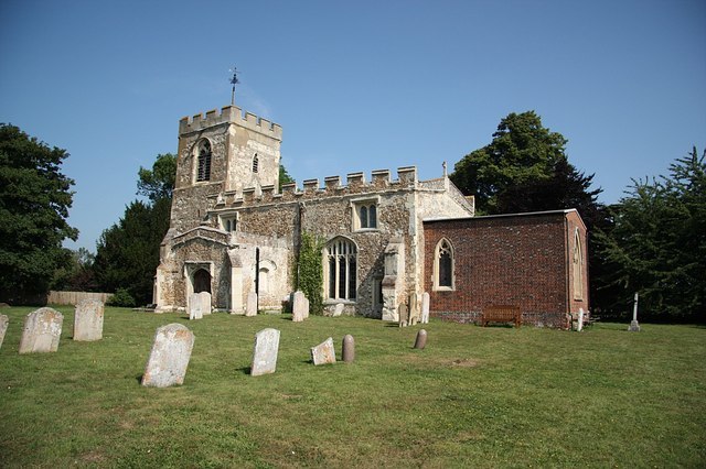
Photo: Richard Croft, CC BY-SA 2.0.
Hinxworth is a village and civil parish in North Hertfordshire, England. It sits just off the Great North Road between Baldock and Biggleswade. It has a village hall, a park, a pub, a small church, a bus stop and a post box.
Caldecote
Village
Photo: John Salmon, CC BY-SA 2.0.
Caldecote is a small village and civil parish in the North Hertfordshire district of Hertfordshire, England. It lies 3 miles north of Baldock, its post town, and around a mile and a half east of Stotfold in the neighbouring county of Bedfordshire.
Newnham
Village

Photo: Tarrier, Public domain.
Newnham is a small village and civil parish in the North Hertfordshire district of Hertfordshire, England. It lies 2 miles north of the town of Baldock.
Hinxworth Place
- Type: House
- Description: medieval manor house near Hinxworth, Hertfordshire, England, UK
- Categories: English country house, manor house, building, historic site, manor estate, and residential building
- Location: Hinxworth, North Hertfordshire District, Hertfordshire, East of England, England, United Kingdom, Britain and Ireland, Europe
- View on OpenStreetMap
Latitude
52.0409° or 52° 2′ 27″ northLongitude
-0.19518° or 0° 11′ 43″ westOpen location code
9C4X2RR3+9WOpenStreetMap ID
way 1420996921OpenStreetMap feature
building=houseOpenStreetMap feature
historic=manorWikidata ID
Q5767761
This page is based on OpenStreetMap, Wikidata, Wikimedia Commons, and Wikipedia.
We’d love your help improving our open data sources. Thank you for contributing.
Satellite Map
Discover Hinxworth Place from above in high-definition satellite imagery.
Notable Places Nearby
Highlights include Christopher’s Wood and Hinxworth Church.
Nearby Places
Explore places such as Dewmead Farm and New Inn Road.
Hertfordshire: Must-Visit Destinations
Delve into St Albans, Watford, Stevenage, and Hertford.
Curious Houses to Discover
Uncover intriguing houses from every corner of the globe.
About Mapcarta. Data © OpenStreetMap contributors and available under the Open Database License". Text is available under the CC BY-SA 4.0 license, except for photos, directions, and the map. Description text is based on the Wikipedia page “Hinxworth Place”. Photo: Wikimedia, CC0.