Centre UCPA - Guadeloupe Les Saintes
Centre UCPA - Guadeloupe Les Saintes is a resort in Guadeloupe. Centre UCPA - Guadeloupe Les Saintes is situated nearby to the beach Plage de Vielle Anse, as well as near Plage de Marigot.| Tap on a place to explore it |
Places of Interest Nearby
Highlights include Fort Napoléon des Saintes and Morel.
Fort Napoléon des Saintes
Fort

Photo: Gauthier Geoffroy, CC BY-SA 4.0.
Fort Napoléon is a fortification, located on Terre-de-Haut Island, in the Îles des Saintes, Guadeloupe. Property of the Departmental Council of Guadeloupe, it has been classified as a historical monument since the December 15, 1997. Fort Napoléon des Saintes is situated 290 metres west of Centre UCPA - Guadeloupe Les Saintes.
Morel
Peak

Photo: Moowgly, CC BY-SA 3.0.
Terre-de-Haut Island is the easternmost island in the Îles des Saintes, part of the archipelago of Guadeloupe. Like name of neighboring Terre-de-Bas Island, name Terre-de-Haut comes from the maritime vocabulary, which called the islands exposed to the "highland" winds and those protected from the wind, "lowlands".
Les Saintes Airport
Aerodrome
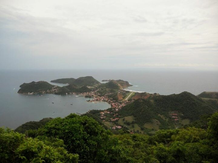
Photo: Moowgly, CC BY-SA 3.0.
Les Saintes Airport is an airport serving the archipelago of Îles des Saintes, French West Indies. It is on an isthmus in the middle of Terre-de-Haut Island, a dependency of Guadeloupe. A special pilot license endorsement is required to land here.
Places in the Area
Nearby places include Marigot and Grande-Anse.
Marigot
Hamlet

Photo: Stéphane Batigne, CC BY 3.0.
Marigot is a quartier of Terre-de-Haut Island, located in Îles des Saintes archipelago in the Caribbean. It is located in the northeastern part of the island.
Grande-Anse
Neighborhood

Photo: Patrice78500, CC BY-SA 3.0.
Grande-Anse is a quartier of Terre-de-Haut Island, located in Îles des Saintes archipelago in the Caribbean. It is located in the eastern part of the island.
Centre UCPA - Guadeloupe Les Saintes
- Type: Resort
- Categories: tourism, accommodation, and building
- Location: Guadeloupe, Lesser Antilles, Caribbean, North America
- View on OpenStreetMap
Latitude
15.87556° or 15° 52′ 32″ northLongitude
-61.5796° or 61° 34′ 47″ westOperator
UCPAOpen location code
777WVCGC+65OpenStreetMap ID
way 1424243390OpenStreetMap feature
tourism=resort
This page is based on OpenStreetMap, Wikidata, and Wikimedia Commons.
We’d love your help improving our open data sources. Thank you for contributing.
Satellite Map
Discover Centre UCPA - Guadeloupe Les Saintes from above in high-definition satellite imagery.
Notable Places Nearby
Highlights include Plage de Vielle Anse and Plage de Marigot.
Nearby Places
Explore places such as centre UCPA and Station Balnéaire de Marigot.
Guadeloupe: Must-Visit Destinations
Delve into Pointe-à-Pitre, Sainte-Anne, Basse-Terre, and Grande-Terre.
Curious Resorts to Discover
Uncover intriguing resorts from every corner of the globe.
About Mapcarta. Data © OpenStreetMap contributors and available under the Open Database License". Text is available under the CC BY-SA 4.0 license, except for photos, directions, and the map. Photo: Patrice78500, CC BY-SA 3.0.