Sign Galaxy
Sign Galaxy is a building in Bradford, England which is located on Wilton Street. Sign Galaxy is situated nearby to the church Deutsche Evangelische Kirche, as well as near the community center Polish Community Centre.| Tap on a place to explore it |
Places of Interest Nearby
Highlights include National Science and Media Museum and Deutsche Evangelische Kirche.
National Science and Media Museum
Museum
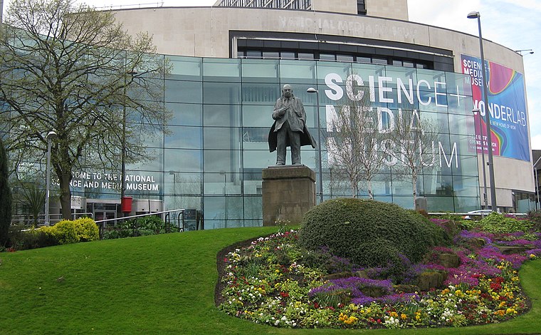
Photo: Chemical Engineer, CC BY-SA 4.0.
The National Science and Media Museum, located in Bradford, West Yorkshire, is part of the national Science Museum Group in the UK. The museum has seven floors of galleries with permanent exhibitions focusing on photography, television, animation, videogaming, the Internet and the scientific principles behind light and colour. National Science and Media Museum is situated 670 feet east of Sign Galaxy.

Odeon Bradford, Prince’s Way
Theater building

Photo: Betty Longbottom, CC BY-SA 2.0.
Odeon Bradford, Prince’s Way is a theater building, which is situated 780 feet northeast of Sign Galaxy.
Places in the Area
Nearby places include Little Germany and Broomfields.
Little Germany
Quarter
Little Germany is an area of particular historical and architectural interest in central Bradford, West Yorkshire, England. The architecture is predominantly neoclassical in style with an Italian influence.
Broomfields
Neighborhood
Broomfields is a historic district on the south eastern edge of Bradford, West Yorkshire, England. In 1840 it was still a mainly rural area with a population of only a few hundred people.
Ripley Ville
Neighborhood

Photo: Betty Longbottom, CC BY-SA 2.0.
Ripley Ville or Ripleyville was an estate of model houses for the working classes in the West Bowling ward of the city of Bradford in West Yorkshire, England.
Sign Galaxy
- Type: Workshop
- Address: 20-22 Wilton Street, Bradford, BD5 0AX
- Category: building
- Location: Bradford, England, United Kingdom, Britain and Ireland, Europe
- View on OpenStreetMap
Latitude
53.79053° or 53° 47′ 26″ northLongitude
-1.75895° or 1° 45′ 32″ westOpen location code
9C5WQ6RR+6COpenStreetMap ID
way 1427113323OpenStreetMap feature
building=yesOpenStreetMap feature
craft=signmaker
This page is based on OpenStreetMap, Wikidata, and Wikimedia Commons.
We’d love your help improving our open data sources. Thank you for contributing.
Satellite Map
Discover Sign Galaxy from above in high-definition satellite imagery.
Notable Places Nearby
Highlights include Polish Community Centre and Fountains Church.
Nearby Places
Explore places such as A2 Lounge and Kashmir Restaurant.
England: Must-Visit Destinations
Delve into London, Manchester, Sheffield, and Leeds.
Curious Places to Discover
Uncover intriguing places from every corner of the globe.
About Mapcarta. Data © OpenStreetMap contributors and available under the Open Database License". Text is available under the CC BY-SA 4.0 license, except for photos, directions, and the map. Photo: Inkey, CC BY 2.0.