Max-Planck-Gymnasium (Trier)
Max-Planck-Gymnasium (Trier) is a school in Trier, Moselle Valley, Rhineland-Palatinate which is located on Sichelstraße. Max-Planck-Gymnasium (Trier) is situated nearby to the garden Schulgarten, as well as near the government office Gebäudewirtschaft Trier (GWT).| Tap on a place to explore it |
Photo: Chris Napp, CC BY-SA 4.0.
- Type: School
- Description: secondary school in Trier, Germany
- Also known as: “MPG Trier”
- Address: Sichelstraße 6, Trier, 54290
- Wheelchair access: no
Places of Interest Nearby
Highlights include Trier Cathedral and Liebfrauenkirche.
Trier Cathedral
Church

Photo: Berthold Werner, CC BY-SA 3.0.
The High Cathedral of Saint Peter in Trier, or Trier Cathedral, is a Roman Catholic cathedral in Trier, Rhineland-Palatinate, Germany. It is the oldest cathedral in Germany and the largest religious structure in Trier, notable for its long life span and grand design. Trier Cathedral is situated 250 metres west of Max-Planck-Gymnasium (Trier).
Liebfrauenkirche
Church

Photo: Berthold Werner, Public domain.
The Liebfrauenkirche in Trier, is, according to UNESCO, "the earliest church built in French High Gothic style outside France." It is designated as part of the Roman Monuments, Cathedral of St Peter and Church of Our Lady in Trier UNESCO World Heritage Site. Liebfrauenkirche is situated 290 metres west of Max-Planck-Gymnasium (Trier).
Aula Palatina
Church
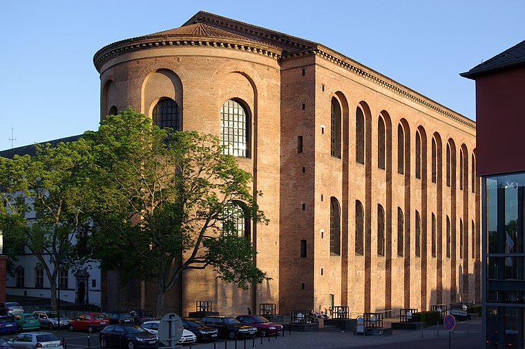
Photo: Berthold Werner, Public domain.
The Aula Palatina, also called Basilica of Constantine, at Trier, Germany, is a Roman palace basilica and an early Christian structure built between AD 300 and 310 during the reigns of Constantius Chlorus and Constantine the Great. Aula Palatina is situated 410 metres southwest of Max-Planck-Gymnasium (Trier).
Places in the Area
Nearby places include Kernscheid and Ruwer/Eitelsbach.
Kernscheid
Suburb

Photo: Wolkenkratzer, CC BY-SA 4.0.
Kernscheid is a suburb, which is situated 4½ km southeast of Max-Planck-Gymnasium (Trier).
Ruwer/Eitelsbach
Suburb
Ruwer/Eitelsbach is a quarter of Trier, Germany. Eitelsbach was a small village at the Ruwer in Germany's Mosel region and famous for the wine estate Karthäuserhof and the associated vineyard Karthäuserhofberg, which means "Carthusians' Hill". Ruwer/Eitelsbach is situated 6 km northeast of Max-Planck-Gymnasium (Trier).
Kasel
Village

Photo: Wikimedia, CC BY-SA 3.0.
Kasel is a municipality in the Trier-Saarburg district, in Rhineland-Palatinate, Germany. Kasel is situated 6 km east of Max-Planck-Gymnasium (Trier).
Max-Planck-Gymnasium (Trier)
- Categories: gymnasium, building, school building, and education
- Location: Trier, Moselle Valley, Rhineland-Palatinate, Germany, Central Europe, Europe
- View on OpenStreetMap
Latitude
49.75636° or 49° 45′ 23″ northLongitude
6.64711° or 6° 38′ 50″ eastOperator
Stadt TrierOpen location code
8FX8QJ4W+GROpenStreetMap ID
way 1427363757OpenStreetMap feature
amenity=schoolOpenStreetMap feature
building=schoolOpenStreetMap attribute
wheelchair=noWikidata ID
Q1912053
This page is based on OpenStreetMap, Wikidata, and Wikimedia Commons.
We’d love your help improving our open data sources. Thank you for contributing.
Satellite Map
Discover Max-Planck-Gymnasium (Trier) from above in high-definition satellite imagery.
In Other Languages
From Esperanto to Romanian—“Max-Planck-Gymnasium (Trier)” goes by many names.
- Esperanto: “Max-Planck-Gymnasium (Trier)”
- Georgian: “მაქს პლანკის გიმნაზია”
- Georgian: “ტრირის მაქს პლანკის გიმნაზია”
- German: “Max-Planck-Gymnasium (Trier)”
- German: “Max-Planck-Gymnasium”
- Romanian: “Max-Planck-Gymnasium (Trier)”
Notable Places Nearby
Highlights include Schulgarten and Gebäudewirtschaft Trier (GWT).
Nearby Places
Explore places such as Max Planck Gymnasium and Alexander Altmann.
Moselle Valley: Must-Visit Destinations
Delve into Cochem, Konz, Traben-Trarbach, and Treis-Karden.
Curious Schools to Discover
Uncover intriguing schools from every corner of the globe.
About Mapcarta. Data © OpenStreetMap contributors and available under the Open Database License". Text is available under the CC BY-SA 4.0 license, except for photos, directions, and the map. Photo: Chris Napp, CC BY-SA 4.0.