A2
A2 is a railway station in Mumbai, Maharashtra. A2 is situated nearby to Ashwini Accident Hospital and Poly Clinic, as well as near the Hindu temple Hanuman Mandir.| Tap on a place to explore it |
Places of Interest Nearby
Highlights include Mahim Fort and Mahim Junction railway station.
Mahim Fort
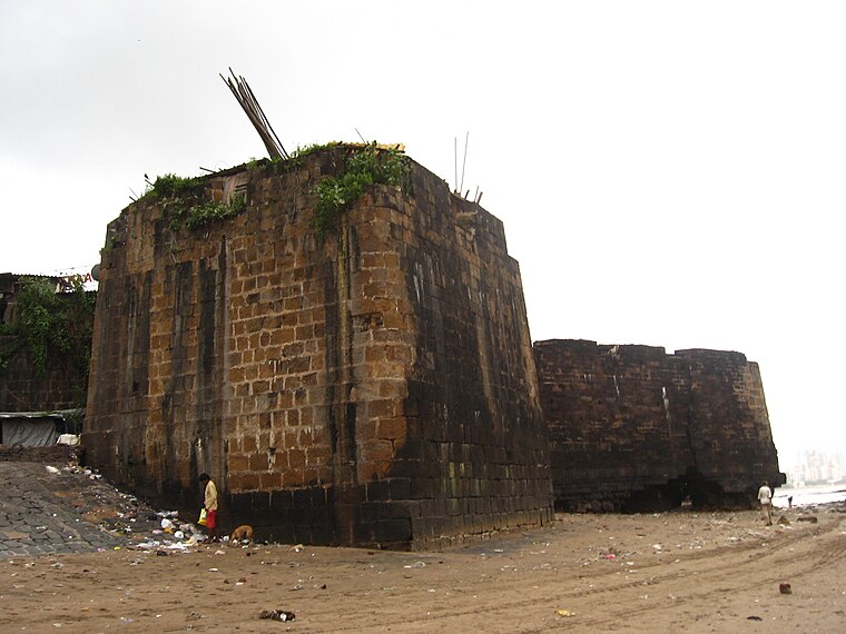
Photo: Nichalp, CC BY-SA 3.0.
The Mahim Fort is a fort in Mahim in Mumbai, Maharashtra state, India. Strategically located on the Mahim Bay, the fort overlooks Worli to the south, Bandra to the north, and Mahim to the east. Mahim Fort is situated 690 metres northwest of A2.
Mahim Junction railway station
Railway station
 Mahim Junction is an Indian railway station on the Western line and Harbour Line of the Mumbai Suburban Railway network. It serves the last town of the Mumbai City district, Mahim. Mahim Junction railway station is situated 570 metres northeast of A2.
St. Michael’s Church
Church

Photo: Nichalp, CC BY-SA 3.0.
St. Michael's Church is one of the oldest Catholic churches in the Mahim suburb of Mumbai, India. Because the church is at the junction of Lady Jamshetjee Road and Mahim Causeway it is sometimes referred to as Mahim Church. St. Michael’s Church is situated 630 metres north of A2.
Places in the Area
Nearby places include Mahim and Dadar.
Mahim
Suburb
Photo: Mehulsg, CC BY-SA 3.0.
Mahim, ) is a neighborhood in Mumbai, Maharashtra, India. The Mahim Junction railway station on the Western Railway and Harbour Railway of the Mumbai Suburban Railway network is the last station of the city, as neighboring Bandra is part of the Mumbai Suburb.
Dadar
Suburb

Photo: Swaminathan, CC BY 2.0.
Dadar is a densely populated residential and shopping neighbourhood in Mumbai. It is also a prominent railway and bus service hub with local and national connectivity. It is Mumbai's first planned area and is a hub for the city's Marathi culture.
Matunga
Suburb
Matunga is a neighbourhood in the city of Mumbai, India. It is accessible from the Matunga Road station on the Western line, Matunga station on the Central Line and King's Circle station on the Harbour Line.
A2
- Type: Railway station
- Categories: building and transportation
- Location: Mumbai, Mumbai District, Maharashtra, Western India, India, South Asia, Asia
- View on OpenStreetMap
Latitude
19.03735° or 19° 2′ 15″ northLongitude
72.84246° or 72° 50′ 33″ eastOpen location code
7JFJ2RPR+WXOpenStreetMap ID
way 1442686584OpenStreetMap feature
building=train_station
This page is based on OpenStreetMap, Wikidata, and Wikimedia Commons.
We’d love your help improving our open data sources. Thank you for contributing.
Satellite Map
Discover A2 from above in high-definition satellite imagery.
Notable Places Nearby
Highlights include Ashwini Accident Hospital and Poly Clinic and Hanuman Mandir.
Nearby Places
Explore places such as ICICI Bank and Amarjeet Auto Store.
Maharashtra: Must-Visit Destinations
Delve into Mumbai, Pune, Nagpur, and Nashik.
Curious Railway Stations to Discover
Uncover intriguing railway stations from every corner of the globe.
About Mapcarta. Data © OpenStreetMap contributors and available under the Open Database License". Text is available under the CC BY-SA 4.0 license, except for photos, directions, and the map. Photo: Mangeshjadhav, CC BY-SA 3.0.