Darwen Aldridge Enterprise Studio
Darwen Aldridge Enterprise Studio is a school in Blackburn with Darwen, England. Darwen Aldridge Enterprise Studio is situated nearby to the health club Darwen Leisure Centre, as well as near Darwen Fire Station.| Tap on a place to explore it |
Places of Interest Nearby
Highlights include Darwen railway station and St Peter’s Church, Darwen.
Darwen railway station
Railway station
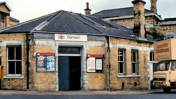
Photo: Albert Bridge, CC BY-SA 2.0.
Darwen railway station serves Darwen, a town in Lancashire, England. It was opened in 1847 by the Bolton, Blackburn, Clitheroe & West Yorkshire Railway, which was subsequently taken over by the Lancashire and Yorkshire Railway twelve years later. Darwen railway station is situated 1,600 feet east of Darwen Aldridge Enterprise Studio.
St Peter’s Church, Darwen
Church

Photo: Chris Coleman, CC BY-SA 2.0.
St Peter's Church is in Bank Street, Darwen, Lancashire, England. It is an active Anglican parish church in the deanery of Blackburn with Darwen, the archdeaconry of Blackburn, and the diocese of Blackburn. St Peter’s Church, Darwen is situated 1,500 feet east of Darwen Aldridge Enterprise Studio.
The Old Chapel
Pub

Photo: The wub, CC BY-SA 4.0.
The Old Chapel is a pub, which is situated 1,300 feet east of Darwen Aldridge Enterprise Studio.
Places in the Area
Nearby places include Darwen and Hoddlesden.
Darwen
Town
Darwen is a market town and civil parish in the Blackburn with Darwen borough in Lancashire, England. The residents of the town are known as "Darreners".
Hoddlesden
Village
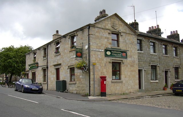
Photo: robert wade, CC BY-SA 2.0.
Hoddlesden is a village in the borough of Blackburn with Darwen, in Lancashire, England. The village population at the 2011 census was 1,239. It is in the borough's East Rural ward, and is situated east of Darwen. Hoddlesden is situated 1½ miles east of Darwen Aldridge Enterprise Studio.
Lower Darwen
Village

Photo: David Dixon, CC BY-SA 2.0.
Lower Darwen is a village in the unitary borough of Blackburn with Darwen, contiguous with the town of Darwen, in the ceremonial county of Lancashire, England. Lower Darwen is situated 1½ miles north of Darwen Aldridge Enterprise Studio.
Darwen Aldridge Enterprise Studio
- Type: School
- Postal code: BB3 1AF
- Category: education
- Location: Blackburn with Darwen, England, United Kingdom, Britain and Ireland, Europe
- View on OpenStreetMap
Latitude
53.69643° or 53° 41′ 47″ northLongitude
-2.471° or 2° 28′ 16″ westOperator
Aldridge EducationOpen location code
9C5VMGWH+HJOpenStreetMap ID
way 1454356413OpenStreetMap feature
amenity=school
This page is based on OpenStreetMap, Wikidata, and Wikimedia Commons.
We’d love your help improving our open data sources. Thank you for contributing.
Satellite Map
Discover Darwen Aldridge Enterprise Studio from above in high-definition satellite imagery.
Notable Places Nearby
Highlights include Darwen Leisure Centre and Central United Reformed Church.
Nearby Places
Explore places such as NHS Short Stay and NHS Staff.
England: Must-Visit Destinations
Delve into London, Manchester, Sheffield, and Leeds.
Curious Places to Discover
Uncover intriguing places from every corner of the globe.
About Mapcarta. Data © OpenStreetMap contributors and available under the Open Database License". Text is available under the CC BY-SA 4.0 license, except for photos, directions, and the map. Photo: sidibousaid, CC BY 2.0.