Fa. Geisen
Fa. Geisen is a building in Mendig, Mayen-Koblenz, Rhineland-Palatinate. Fa. Geisen is situated nearby to the health club Vitafun Fitnessstudio, as well as near the railway station Mendig station.| Tap on a place to explore it |
Places of Interest Nearby
Highlights include Mendig station and Mendig Air Base.
Mendig station
Railway station

Photo: Tohma, CC BY-SA 4.0.
Mendig is a station in the town of Mendig in the German state of Rhineland-Palatinate. It was called Niedermendig until 1877. It is located on the Cross Eifel Railway, which has two tracks from Andernach station and continues as a single track to Gerolstein station. Mendig station is situated 540 metres west of Fa. Geisen.
Mendig Air Base
Aerodrome
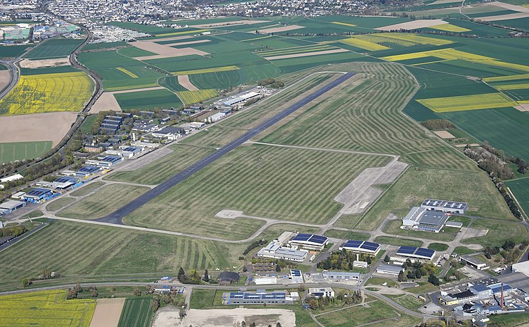
Photo: Carsten Steger, CC BY-SA 4.0.
Mendig Air Base is a former military air base located southeast of the city of Mendig, Rhineland-Palatinate, Germany. It was home of German Army Medium Transport Helicopter Regiment 35, equipped with CH-53D helicopters.
Lava-Dome Mendig
Museum

Photo: Schaengel, CC BY-SA 3.0 de.
Lava-Dome Mendig is a museum, which is situated 1½ km northwest of Fa. Geisen.
Places in the Area
Nearby places include Thür and Fraukirch.
Thür
Village

Photo: Historiograf, CC BY 2.0.
Thür is a municipality in the district of Mayen-Koblenz in Rhineland-Palatinate, western Germany.

Kruft
Village

Photo: Labradormix, Public domain.
Kruft is a municipality in the district of Mayen-Koblenz in Rhineland-Palatinate, western Germany. It is home to Laach Castle, a burgstall and former spur castle by the Laacher See lake. Kruft is situated 3½ km northeast of Fa. Geisen.
Fa. Geisen
- Type: Building
- Location: Mendig, Mayen-Koblenz, Rhineland-Palatinate, Germany, Central Europe, Europe
- View on OpenStreetMap
Latitude
50.36811° or 50° 22′ 5″ northLongitude
7.29829° or 7° 17′ 54″ eastOpen location code
9F29979X+68OpenStreetMap ID
way 175378978OpenStreetMap feature
building=yes
This page is based on OpenStreetMap, Wikidata, and Wikimedia Commons.
We’d love your help improving our open data sources. Thank you for contributing.
Satellite Map
Discover Fa. Geisen from above in high-definition satellite imagery.
Notable Places Nearby
Highlights include Vitafun Fitnessstudio and Kaiserbahnhof Mendig.
Nearby Places
Explore places such as Netto Marken-Discount and Rossmann.
Rhineland-Palatinate: Must-Visit Destinations
Delve into Mainz, Trier, Koblenz, and Worms.
Curious Buildings to Discover
Uncover intriguing buildings from every corner of the globe.
About Mapcarta. Data © OpenStreetMap contributors and available under the Open Database License". Text is available under the CC BY-SA 4.0 license, except for photos, directions, and the map. Photo: Traveler100, CC BY-SA 3.0.