Segel-Club Oevelgönne v. 1901
Segel-Club Oevelgönne v. 1901 is a building in Hamburg, Germany. Segel-Club Oevelgönne v. 1901 is situated nearby to the sports venue Elb-Segler-Vereinigung, as well as near Ms Altenwerder.| Tap on a place to explore it |
Places of Interest Nearby
Highlights include Bubendey-Ufer Oberfeuer and Der Alte Schwede.
Bubendey-Ufer Oberfeuer
Lighthouse

Photo: Gerhard kemme, CC0.
Bubendey-Ufer Oberfeuer is a lighthouse, which is situated 800 metres northeast of Segel-Club Oevelgönne v. 1901.
Der Alte Schwede
Stone

Photo: Wmeinhart, CC BY-SA 3.0.
Der Alte Schwede or Alter Schwede is a glacial erratic in Germany. Der Alte Schwede is situated 1½ km north of Segel-Club Oevelgönne v. 1901.
Pilot station Seemannshöft
Heritage site
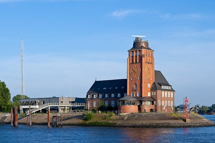
Photo: Torsten Bätge, CC BY-SA 3.0.
Pilot station Seemannshöft is a heritage site, which is situated 1¼ km northwest of Segel-Club Oevelgönne v. 1901.
Places in the Area
Nearby places include Waltershof and Finkenwerder.
Waltershof
Suburb

Photo: Sebastian Warneke, CC BY 2.0.
Waltershof is a quarter in the Hamburg-Mitte borough of the Free and Hanseatic city of Hamburg in northern Germany. It is a part of the Port of Hamburg.
Finkenwerder
Suburb

Photo: Mogelzahn, CC BY-SA 2.5.
Finkenwerder is a quarter of Hamburg, Germany in the borough Hamburg-Mitte. It is the location of the Hamburg Airbus plant and its airport. In 2016 the population was 11,668.
Othmarschen
Suburb

Photo: Sebastian scha., CC BY-SA 3.0.
Othmarschen is a quarter in the Altona borough of Hamburg in northern Germany. In 2020 the population was 16,009. Othmarschen is situated 2½ km north of Segel-Club Oevelgönne v. 1901.
Segel-Club Oevelgönne v. 1901
- Type: Building
- Location: Hamburg, Germany, Central Europe, Europe
- View on OpenStreetMap
Latitude
53.53199° or 53° 31′ 55″ northLongitude
9.8923° or 9° 53′ 32″ eastOpen location code
9F5FGVJR+QWOpenStreetMap ID
way 180155816OpenStreetMap feature
building=boathouse
This page is based on OpenStreetMap, Wikidata, and Wikimedia Commons.
We’d love your help improving our open data sources. Thank you for contributing.
Satellite Map
Discover Segel-Club Oevelgönne v. 1901 from above in high-definition satellite imagery.
Notable Places Nearby
Highlights include Elb-Segler-Vereinigung and Ms Altenwerder.
Nearby Places
Explore places such as SWOP and SWOP Seaworthy Packing.
Hamburg: Must-Visit Destinations
Delve into Altona-St. Pauli, Neustadt-Altstadt, East Hamburg, and North Hamburg.
Curious Buildings to Discover
Uncover intriguing buildings from every corner of the globe.
About Mapcarta. Data © OpenStreetMap contributors and available under the Open Database License". Text is available under the CC BY-SA 4.0 license, except for photos, directions, and the map. Photo: Joerg Moellenkamp, CC BY 2.0.