Doho University
Doho University is an university in Nakamura Ward, Nagoya, Aichi. Doho University is situated nearby to Doho High School, as well as near 神明社.| Tap on a place to explore it |
Places of Interest Nearby
Highlights include shichisyo-sha and Hatta.
shichisyo-sha
Shinto shrine

Photo: Bariston, CC BY-SA 4.0.
shichisyo-sha is a Shinto shrine, which is situated 640 metres southwest of Doho University.
Hatta
Railway station

Photo: Gnsin, CC BY-SA 3.0.
Hatta Station is a joint-use railway and subway station located in Nakamura-ku, Nagoya, Aichi Prefecture, Japan. It is located 3.1 rail kilometres from the terminus of the Kansai Line at Nagoya Station and is 0.9 kilometers from the terminus of the Hiagashiyama Line at Takabata Station. Hatta is situated 2 km southeast of Doho University.
Ryōun-ji Temple
Buddhist temple

Photo: Bariston, CC BY-SA 3.0.
Ryōun-ji Temple is a Buddhist temple, which is situated 1 km northwest of Doho University.
Places in the Area
Nearby places include Ōharu and Nishi Ward.
Ōharu
Town

Photo: Wikimedia, CC BY-SA 4.0.
Ōharu is a town located in Ama District, Aichi Prefecture, Japan. As of 1 October 2019, the town had an estimated population of 32,318 in 13,683 households, and a population density of 4,904 persons per km².
Nishi Ward
Suburb

Photo: Nagono, CC BY-SA 3.0.
Nishi-ku is one of the 16 wards in the city of Nagoya in Aichi Prefecture, Japan. As of 1 October 2019, the ward has an estimated population of 150,480 and a population density of 8,393 persons per km2. The total area is 17.93 km2. Nishi Ward is situated 5 km northeast of Doho University.
Nagoya Castle
Locality
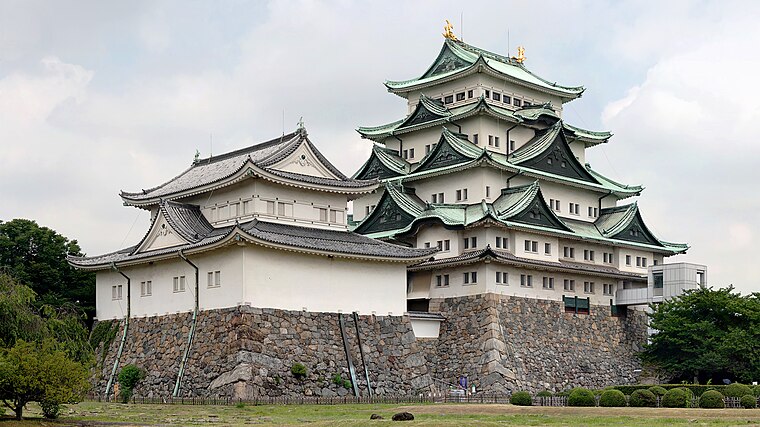
Photo: Base64, CC BY-SA 3.0.
Nagoya Castle is a Japanese castle located in Nagoya, Japan. Nagoya Castle was constructed by the Owari Domain in 1612 during the Edo period on the site of an earlier castle of the Oda clan in the Sengoku period. Nagoya Castle is situated 6 km northeast of Doho University.
Doho University
- Type: University
- Category: education
- Location: Nakamura Ward, Nagoya, Aichi, Chubu, Japan, East Asia, Asia
- View on OpenStreetMap
Latitude
35.16371° or 35° 9′ 49″ northLongitude
136.84331° or 136° 50′ 36″ eastOpen location code
8Q7R5R7V+F8OpenStreetMap ID
way 230452574OpenStreetMap feature
amenity=university
This page is based on OpenStreetMap, Wikidata, and Wikimedia Commons.
We’d love your help improving our open data sources. Thank you for contributing.
Satellite Map
Discover Doho University from above in high-definition satellite imagery.
In Other Languages
“Doho University” goes by many names.
- Japanese: “同朋大学”
Notable Places Nearby
Highlights include Doho High School and 神明社.
Nearby Places
Explore places such as 名古屋音楽大学 and 同朋幼稚園.
Aichi: Must-Visit Destinations
Delve into Toyota, Toyohashi, Okazaki, and Ichinomiya.
Curious Places to Discover
Uncover intriguing places from every corner of the globe.
About Mapcarta. Data © OpenStreetMap contributors and available under the Open Database License". Text is available under the CC BY-SA 4.0 license, except for photos, directions, and the map. Photo: AndreCarrotflower, CC BY-SA 3.0.