Ministère de l’Environnement وزارة البيئة
Ministère de l’Environnement وزارة البيئة is a town hall in Ksar, Nouakchott-Ouest region which is located on شارع 21-185. Ministère de l’Environnement وزارة البيئة is situated nearby to the government office Direction de l’inspection فرع الفحص, as well as near the university Université Cheikh Mohamed Lemine Chinguitti جامعة الشيخ محمد الأمين الشنقيطي.| Tap on a place to explore it |
- Opening hours: Monday—Saturday 8:00 AM—6:00 PM
- Type: Town hall
- Address: 838 شارع 21-185, القصر, نواكشوط, 170
Places of Interest Nearby
Highlights include National Museum of Mauritania and National Library of Mauritania.
National Museum of Mauritania
Museum
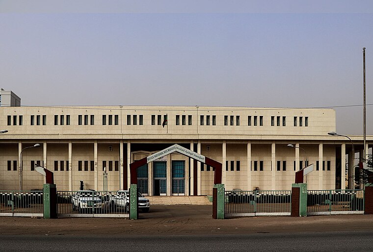
Photo: Clemens Schmillen, CC BY-SA 4.0.
The National Museum of Mauritania, also known as the National Museum of Nouakchott, is a national museum in Nouakchott, Mauritania. It is located to the southwest of the Hotel Mercure Marhaba, west of Hotel de Ville, northwest of Parc Deydouh, and northeast of the Mosque Ould Abbas. National Museum of Mauritania is situated 1 km northwest of Ministère de l’Environnement وزارة البيئة.
National Library of Mauritania
Library
Photo: Clemens Schmillen, CC BY-SA 4.0.
The Bibliothèque Nationale de Mauritanie is located in Nouakchott, Mauritania in the building of the National Museum of Mauritania. The library has a collection of 10,000 volumes and employs 41 staff members. The library has seven branches. National Library of Mauritania is situated 1 km northwest of Ministère de l’Environnement وزارة البيئة.
G5 Sahel
Government office
G5 Sahel or G5S was an institutional framework for coordination of regional cooperation in development policies and security matters in West Africa. It was created on 16 February 2014 in Nouakchott, Mauritania, at a summit of five Sahel countries: Burkina Faso, Chad, Mali, Mauritania, and Niger. G5 Sahel is situated 2½ km northwest of Ministère de l’Environnement وزارة البيئة.
Places in the Area
Nearby places include Nouakchott and Ksar.
Nouakchott

Photo: Jjtkk, CC BY-SA 3.0.
Nouakchott is the capital of Mauritania and its largest city, with almost 1.2 million residents in 2019. The city is the hub of the Mauritanian economy and is home to a deepwater port and Nouakchott–Oumtounsy International Airport, one of the country's two international airports.
Ksar
Suburb
Ksar, Mauritania is a suburb of Nouakchott and urban commune in western Mauritania. It has a population of 43,531. Ksar is situated 3 km north of Ministère de l’Environnement وزارة البيئة.
Sebkha
Suburb
Sebkha is a suburb of Nouakchott and urban commune in western Mauritania. It has a population of 72,245. The football teams ASC Nasr de Sebkha and ASC Socogim are based there. Sebkha is situated 3½ km west of Ministère de l’Environnement وزارة البيئة.
Ministère de l’Environnement وزارة البيئة
- Categories: commerce and government building
- Location: Ksar, Nouakchott-Ouest region, Mauritania, Sahel, Africa
- View on OpenStreetMap
Latitude
18.07929° or 18° 4′ 46″ northLongitude
-15.96851° or 15° 58′ 7″ westOpen location code
7CC632HJ+PHOpenStreetMap ID
way 240237250OpenStreetMap feature
amenity=townhallOpenStreetMap feature
landuse=commercial
This page is based on OpenStreetMap, Wikidata, and Wikimedia Commons.
We’d love your help improving our open data sources. Thank you for contributing.
Satellite Map
Discover Ministère de l’Environnement وزارة البيئة from above in high-definition satellite imagery.
In Other Languages
From Arabic to French—“Ministère de l’Environnement وزارة البيئة” goes by many names.
- Arabic: “وزارة البيئة”
- French: “Ministère de l’Environnement”
Notable Places Nearby
Highlights include Ministère de l’environnement وزارة البيئة and Direction de l’inspection فرع الفحص.
Nearby Places
Explore places such as Ministère de l’élevage وزارة الثروة الحيوانية and École Polytechnique المدرسة المتعددة التكنولوجية.
Mauritania: Must-Visit Destinations
Delve into Nouakchott, Nouadhibou, Banc d’Arguin National Park, and Atar.
Curious Town Halls to Discover
Uncover intriguing town halls from every corner of the globe.
About Mapcarta. Data © OpenStreetMap contributors and available under the Open Database License". Text is available under the CC BY-SA 4.0 license, except for photos, directions, and the map. Photo: Wikimedia, CC0.