Urbanización Colinas de Pirineos
Urbanización Colinas de Pirineos is a neighborhood in Municipio San Cristóbal, Táchira. Urbanización Colinas de Pirineos is situated nearby to the suburb Pirineos 2, as well as near Pirineos 1.| Tap on a place to explore it |
Places of Interest
Highlights include Estadio Polideportivo de Pueblo Nuevo and Estadio Metropolitano de San Cristóbal.
Estadio Polideportivo de Pueblo Nuevo
Stadium
Estadio Polideportivo de Pueblo Nuevo is a multi-purpose stadium in San Cristóbal, Venezuela. It is currently used mostly for football matches and is the home stadium of Deportivo Táchira Fútbol Club.
Estadio Metropolitano de San Cristóbal
Stadium
 Estadio Metropolitano is a multi-use stadium in San Cristóbal, Venezuela. It is currently used mostly for baseball games. The stadium holds 22,000 people. Estadio Metropolitano de San Cristóbal is situated 2½ km north of Urbanización Colinas de Pirineos.
San Cristóbal Paramillo Airport
Aerodrome
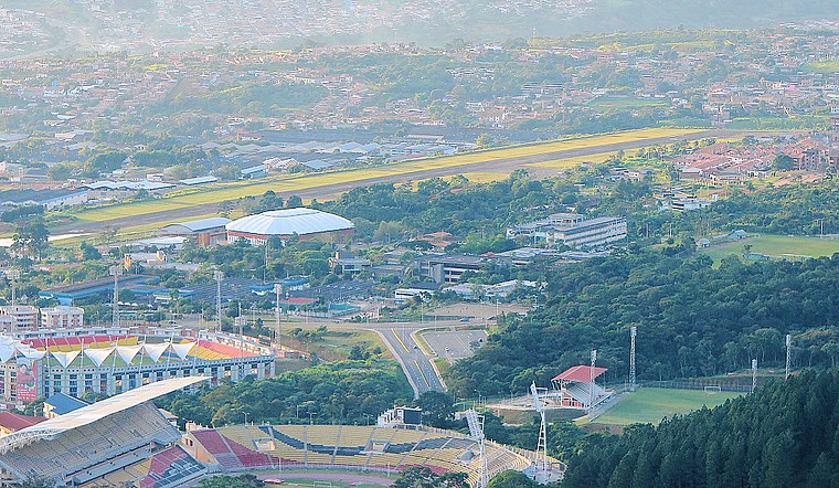
Photo: Unukalhai, CC BY-SA 3.0.
Paramillo Airport is an airport serving San Cristóbal, the capital of the Táchira state of Venezuela. The runway is in Paramillo, 4 kilometres north of San Cristóbal. The Paramillo non-directional beacon is located on the field. San Cristóbal Paramillo Airport is situated 4 km north of Urbanización Colinas de Pirineos.
Places in the Area
Nearby places include San Cristóbal and Táriba.
San Cristóbal

Photo: Rufino, CC BY-SA 2.0.
San Cristobal is a leafy, prosperous city of west Venezuela. The city is in a mountainous valley in the temperate green hills of the Andes bordering Colombia.
Táriba
Town

Photo: Tariba1, CC BY-SA 3.0.
Táriba is a town in Táchira, Venezuela, and is the capital of the Cárdenas Municipality. It was founded in 1602. Táriba has a population of 128,590. It's located on the outsides of the city of San Cristóbal. Táriba is situated 6 km northwest of Urbanización Colinas de Pirineos.
Palmira
Town
Palmira is a town in Táchira, Venezuela. It is the capital of Guásimos Municipality. It was founded in 1627 by Fernando Saavedra and in 1642 by Captain Luis Sosa Lovera. In 2011, it had a population of 43.236. Palmira is situated 8 km north of Urbanización Colinas de Pirineos.
Urbanización Colinas de Pirineos
- Type: Neighborhood
- Categories: residential area and locality
- Location: Municipio San Cristóbal, Táchira, Andes, Venezuela, South America
- View on OpenStreetMap
Latitude
7.76695° or 7° 46′ 1″ northLongitude
-72.20001° or 72° 12′ westOpen location code
67V9QQ8X+QXOpenStreetMap ID
way 243819077OpenStreetMap feature
landuse=residentialOpenStreetMap feature
place=neighbourhood
This page is based on OpenStreetMap, Wikidata, and Wikimedia Commons.
We’d love your help improving our open data sources. Thank you for contributing.
Satellite Map
Discover Urbanización Colinas de Pirineos from above in high-definition satellite imagery.
Localities in the Area
Explore places such as Pirineos 2 and Pirineos 1.
Notable Places Nearby
Highlights include Canchas Colegio de Ingenieros and Cancha de Barrio Sucre.
Andes: Must-Visit Destinations
Delve into Mérida, Trujillo, San Cristóbal, and Santo Domingo.
Curious Neighborhoods to Discover
Uncover intriguing neighborhoods from every corner of the globe.
About Mapcarta. Data © OpenStreetMap contributors and available under the Open Database License". Text is available under the CC BY-SA 4.0 license, except for photos, directions, and the map. Photo: Wikimedia, CC0.