open space
open space is a recreation area in Municipality of Morong, Rizal, Calabarzon. open space is situated nearby to Viewing Deck, as well as near Swimming Pool.| Tap on a place to explore it |
Places of Interest Nearby
Highlights include Morong Plaza and Tomas Claudio Memorial Elementary School.
Morong Plaza
Park
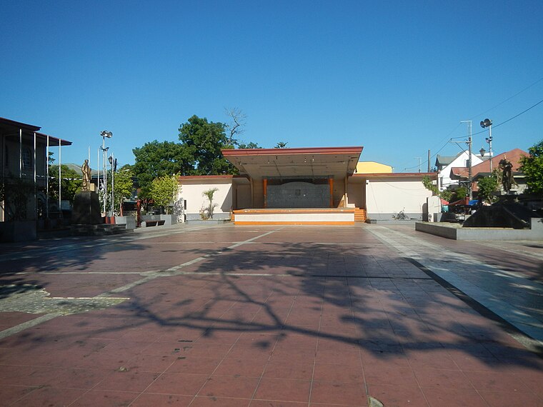
Photo: Judgefloro, CC0.
Morong Plaza is a park, which is situated 2 km east of open space.
Tomas Claudio Memorial Elementary School
School

Photo: Hannachiever07, CC BY-SA 3.0.
Tomas Claudio Memorial Elementary School, formerly called Tomas Claudio Memorial School, was constructed in 1921 in honor of Private Tomas Mateo Claudio, the first Filipino hero of Morong, Rizal, in the Philippines, who died during World War I in France. Tomas Claudio Memorial Elementary School is situated 2 km east of open space.
Morong historical marker
Memorial

Photo: Ramon FVelasquez, CC BY-SA 3.0.
Morong historical marker is a memorial, which is situated 2 km east of open space.
Places in the Area
Nearby places include Morong and Cardona.
Morong
Town
Photo: Ramon FVelasquez, CC BY-SA 3.0.
Morong, officially the Municipality of Morong, is a municipality located in the province of Rizal, Philippines. As per the 2024 census, Morong has a population of 72,262 people.
Cardona
Town

Photo: Ramon FVelasquez, CC BY-SA 3.0.
Cardona, officially the Municipality of Cardona, is a municipality in the province of Rizal, Philippines. According to the 2024 census, it has a population of 51,493 people. Cardona is situated 3½ km south of open space.
Baras
Town

Photo: Ramon FVelasquez, CC BY-SA 3.0.
Baras, officially the Municipality of Baras, is a municipality in the province of Rizal, Philippines. According to the 2024 census, it has a population of 91,099 people. Baras is 32 kilometers from Antipolo and 49 kilometers from Manila. Baras is situated 5 km east of open space.
open space
- Type: Common land
- Category: recreation area
- Location: Municipality of Morong, Rizal, Calabarzon, Luzon, Philippines, Southeast Asia, Asia
- View on OpenStreetMap
Latitude
14.51441° or 14° 30′ 52″ northLongitude
121.21982° or 121° 13′ 11″ eastOpen location code
7Q63G679+QWOpenStreetMap ID
way 267707218OpenStreetMap feature
leisure=common
This page is based on OpenStreetMap, Wikidata, and Wikimedia Commons.
We’d love your help improving our open data sources. Thank you for contributing.
Satellite Map
Discover open space from above in high-definition satellite imagery.
Places with the Same Name
Discover other places named “open space”.
Notable Places Nearby
Highlights include Viewing Deck and Swimming Pool.
Nearby Places
Explore places such as Demo Farms Nursery and Demo Farm 2.
Rizal: Must-Visit Destinations
Delve into Antipolo, Cainta, Rodriguez, and Angono.
Curious Places to Discover
Uncover intriguing places from every corner of the globe.
About Mapcarta. Data © OpenStreetMap contributors and available under the Open Database License". Text is available under the CC BY-SA 4.0 license, except for photos, directions, and the map. Photo: Wikimedia, CC0.