Westerkogge
Westerkogge is a pumping station in Koggenland Municipality, North Holland which is located on IJselmeerdijk. Westerkogge is situated nearby to the cemetery Algemene Begraafplaats, as well as near the village Scharwoude.| Tap on a place to explore it |
Places of Interest Nearby
Highlights include Station Avenhorn and Hoorn railway station.
Station Avenhorn
House

Photo: Janna van B, CC BY-SA 3.0 nl.
Station Avenhorn is a house, which is situated 660 metres southwest of Westerkogge.
Hoorn railway station
Railway station
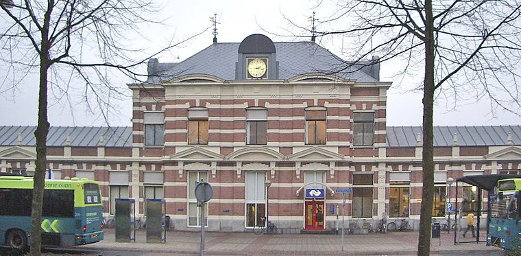
Photo: T Houdijk, CC BY-SA 3.0.
Hoorn is the main railway station of the town of Hoorn, Netherlands. Hoorn railway station is situated 3½ km northeast of Westerkogge.
Schouwburg Het Park
Theater building

Photo: Michiel1972, Public domain.
Schouwburg Het Park is a theater building, which is situated 3 km northeast of Westerkogge.
Places in the Area
Nearby places include Scharwoude and De Hulk.
Scharwoude
Village
Scharwoude is a village in the Dutch province of North Holland. It is a part of the municipality of Koggenland, and lies about 5 km southwest of Hoorn.
De Hulk
Hamlet
De Hulk is a hamlet and nature reserve in the municipalities of Koggenland and Hoorn in the Dutch province of North Holland.
Berkhout
Village
Berkhout is a village in the northwest Netherlands. It is in the municipality of Koggenland, North Holland, about 5 km west of Hoorn.
Westerkogge
- Type: Pumping station
- Address: IJselmeerdijk 6D, Scharwoude, 1634DM
- Categories: building and industry
- Location: Koggenland Municipality, North Holland, Western Netherlands, Netherlands, Benelux, Europe
- View on OpenStreetMap
Latitude
52.62485° or 52° 37′ 30″ northLongitude
5.01493° or 5° 0′ 54″ eastInception
1982Open location code
9F47J2F7+WXOpenStreetMap ID
way 278196274OpenStreetMap feature
building=yesOpenStreetMap feature
man_made=pumping_stationOpenStreetMap feature
waterway=pumping_station
This page is based on OpenStreetMap, Wikidata, and Wikimedia Commons.
We’d love your help improving our open data sources. Thank you for contributing.
Satellite Map
Discover Westerkogge from above in high-definition satellite imagery.
Places with the Same Name
Discover other places named “Westerkogge”.
Notable Places Nearby
Highlights include Algemene Begraafplaats and De Hulk.
Nearby Places
Explore places such as Strukton Civiel Regio West and Ooms.
North Holland: Must-Visit Destinations
Delve into Amsterdam, Haarlem, Alkmaar, and Schiphol Airport.
Curious Pumping Stations to Discover
Uncover intriguing pumping stations from every corner of the globe.
About Mapcarta. Data © OpenStreetMap contributors and available under the Open Database License". Text is available under the CC BY-SA 4.0 license, except for photos, directions, and the map. Photo: Arch, Public domain.