Haarstudio topline
Haarstudio topline is a hairdresser in Lautertal, Landkreis Coburg, Bavaria which is located on Stetsambach. Haarstudio topline is situated nearby to Holy Trinity church (Unterlauter), as well as near the church Kirchturm.| Tap on a place to explore it |
- Opening hours:
Tuesday and Thursday: 8:30 AM—8:00 PM
Wednesday and Friday: 8:30 AM—6:00 PM
Sunday: 8:00 AM—2:00 PM - Type: Hairdresser
- Address: Stetsambach 2a, Lautertal, 96486
Places of Interest Nearby
Highlights include Holy Trinity church (Unterlauter) and Coburg Fortress.
Holy Trinity church (Unterlauter)
Church

Photo: Wikimedia, CC BY-SA 3.0 de.
Holy Trinity church (Unterlauter) is situated 180 metres north of Haarstudio topline.
Coburg Fortress
Castle
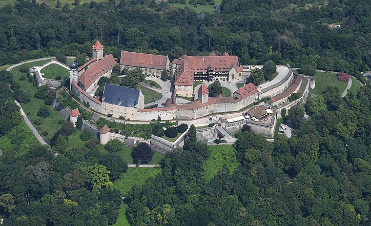
Photo: Carsten Steger, CC BY-SA 4.0.
The Veste Coburg is one of the best-preserved medieval fortresses of Germany. It is situated on a hill above the town of Coburg, in the Upper Franconia region of Bavaria. Coburg Fortress is situated 3½ km south of Haarstudio topline.
Kirche
Church

Photo: Wikimedia, CC BY-SA 3.0 de.
Kirche is a church, which is situated 1½ km north of Haarstudio topline.
Places in the Area
Nearby places include Unterlauter and Bertelsdorf.


Haarstudio topline
- Categories: building and shop
- Location: Lautertal, Landkreis Coburg, Upper Franconia, Franconia, Bavaria, Germany, Central Europe, Europe
- View on OpenStreetMap
Latitude
50.29657° or 50° 17′ 48″ northLongitude
10.97733° or 10° 58′ 38″ eastOperator
Carmen SchultheißOpen location code
9F2G7XWG+JWOpenStreetMap ID
way 282639588OpenStreetMap feature
building=yesOpenStreetMap feature
shop=hairdresser
This page is based on OpenStreetMap, Wikidata, and Wikimedia Commons.
We’d love your help improving our open data sources. Thank you for contributing.
Satellite Map
Discover Haarstudio topline from above in high-definition satellite imagery.
Places with the Same Name
Discover other places named “Haarstudio topline”.
Notable Places Nearby
Highlights include Kirchturm and Friedhof Lautertal.
Nearby Places
Explore places such as Schreinerei Büttner and Unterlauter Süd.
Upper Franconia: Must-Visit Destinations
Delve into Bamberg, Bayreuth, Coburg, and Hof.
Curious Hairdressers to Discover
Uncover intriguing hairdressers from every corner of the globe.
About Mapcarta. Data © OpenStreetMap contributors and available under the Open Database License". Text is available under the CC BY-SA 4.0 license, except for photos, directions, and the map. Photo: Wikimedia, CC0.