Das Grüne Warenhaus Rathjen
Das Grüne Warenhaus Rathjen is a garden center in Fehmarn, Ostholstein, Schleswig-Holstein which is located on Sahrensdorfer Straße. Das Grüne Warenhaus Rathjen is situated nearby to the fire station Freiwillige Feuerwehr Burg, as well as near Peter Wiepert Heimatmuseum.| Tap on a place to explore it |
- Type: Garden center
- Address: Sahrensdorfer Straße 12, Burg auf Fehmarn, Fehmarn, 23769
- Wheelchair access: yes
Places of Interest Nearby
Highlights include St. Nicholas Church, Fehmarn and Rathaus Burg auf Fehmarn.
St. Nicholas Church, Fehmarn
Church

Photo: Beckstet, CC BY-SA 3.0.
St. Nicholas Church is a church in the city of Burg on the German Baltic island of Fehmarn. St. Nicholas Church, Fehmarn is situated 200 metres west of Das Grüne Warenhaus Rathjen.
Rathaus Burg auf Fehmarn
Town hall
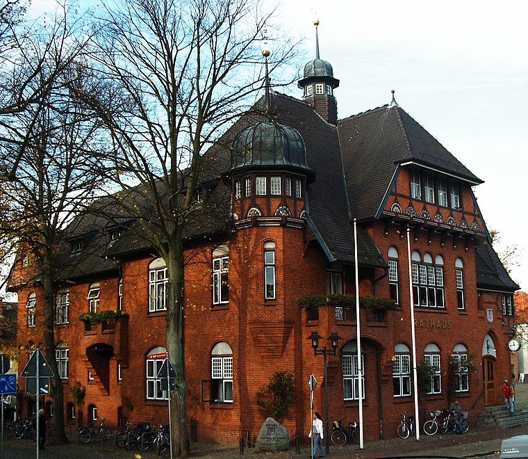
Photo: S.moeller, Public domain.
Rathaus Burg auf Fehmarn is a town hall, which is situated 300 metres northwest of Das Grüne Warenhaus Rathjen.
Breite Straße 10
Restaurant

Photo: Gerd Fahrenhorst, CC BY 4.0.
Breite Straße 10 is a restaurant, which is situated 210 metres north of Das Grüne Warenhaus Rathjen.
Places in the Area
Nearby places include Burg auf Fehmarn and Burgstaaken.


Landkirchen auf Fehmarn
Village

Photo: Torbenbrinker, CC BY-SA 3.0.
Landkirchen auf Fehmarn is a village, which is situated 3½ km northwest of Das Grüne Warenhaus Rathjen.
Das Grüne Warenhaus Rathjen
- Categories: building and shop
- Location: Fehmarn, Ostholstein, East Holstein, Schleswig-Holstein, Germany, Central Europe, Europe
- View on OpenStreetMap
Latitude
54.43656° or 54° 26′ 12″ northLongitude
11.19917° or 11° 11′ 57″ eastOpen location code
9F6HC5PX+JMOpenStreetMap ID
way 288791906OpenStreetMap feature
building=yesOpenStreetMap feature
shop=garden_centreOpenStreetMap attribute
wheelchair=yes
This page is based on OpenStreetMap, Wikidata, and Wikimedia Commons.
We’d love your help improving our open data sources. Thank you for contributing.
Satellite Map
Discover Das Grüne Warenhaus Rathjen from above in high-definition satellite imagery.
Notable Places Nearby
Highlights include Freiwillige Feuerwehr Burg and Peter Wiepert Heimatmuseum.
Nearby Places
Explore places such as KüstenManufaktur and Störtebecker.
East Holstein: Must-Visit Destinations
Delve into Lübeck, Ratzeburg, Timmendorfer Strand, and Grömitz.
Curious Garden Centers to Discover
Uncover intriguing garden centers from every corner of the globe.
About Mapcarta. Data © OpenStreetMap contributors and available under the Open Database License". Text is available under the CC BY-SA 4.0 license, except for photos, directions, and the map. Photo: Wikimedia, Public domain.