115 Ave Super Market
115 Ave Super Market is a supermarket in Edmonton, Edmonton Capital Region, Alberta. 115 Ave Super Market is situated nearby to Edmonton Spanish Seventh Day Adventist Church, as well as near Lorne Street Park.| Tap on a place to explore it |
Places of Interest Nearby
Highlights include Commonwealth Stadium and Northlands Coliseum.
Commonwealth Stadium
Stadium
Commonwealth Stadium is an open-air, multi-purpose stadium located in the McCauley neighbourhood of Edmonton, Alberta, Canada. It has a seating capacity of 56,302, making it the largest stadium in Canada. Commonwealth Stadium is situated 780 metres southeast of 115 Ave Super Market.
Northlands Coliseum
Stadium
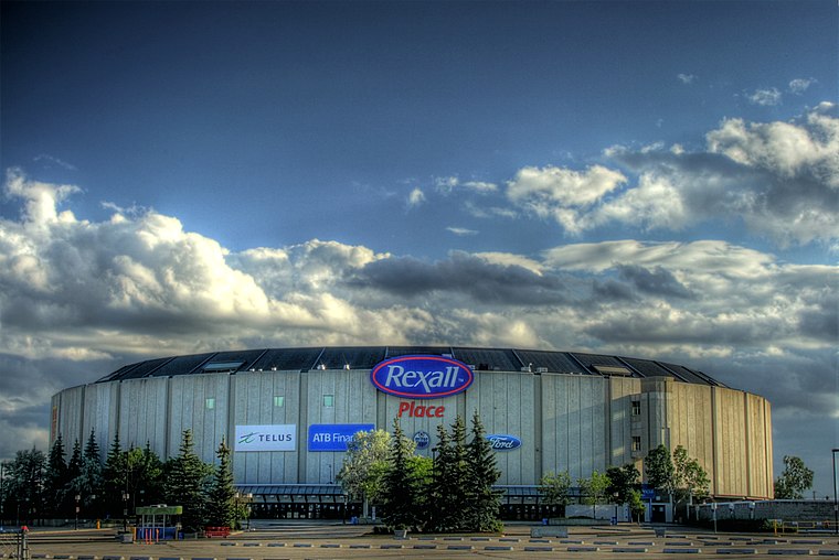
Photo: WinterE229, CC0.
Northlands Coliseum is a defunct indoor arena in Edmonton, Alberta. It was used for sports events and concerts, and was home to the Edmonton Oilers of the World Hockey Association and National Hockey League, and the Edmonton Oil Kings of the Western Hockey League. Northlands Coliseum is situated 2 km east of 115 Ave Super Market.
Clarke Stadium
Pitch
 Clarke Stadium is a multipurpose stadium located in Edmonton, Alberta, Canada. The stadium was originally built for Canadian football. Over the years different sports have participated at the site. Clarke Stadium is situated 1 km south of 115 Ave Super Market.
Places in the Area
Nearby places include Alberta Avenue and Parkdale.
Alberta Avenue
Neighborhood

Photo: Johntwrl, CC BY-SA 3.0.
Alberta Avenue is a pre–World War II neighbourhood in Edmonton, Alberta, Canada. Alberta Avenue is a mature, inner city neighbourhood in Edmonton, Alberta.
Parkdale
Neighborhood
Parkdale is a central neighbourhood in Edmonton, Alberta, Canada located a short distance north of the downtown core. Located to the south of the neighbourhood is Commonwealth Stadium and to the north east is Northlands Coliseum.
McCauley
Neighborhood

Photo: WinterE229, CC0.
McCauley is an ethnically diverse inner city neighbourhood in Edmonton, Alberta, Canada. It is named for Matthew McCauley, the first mayor of Edmonton, and is located just to the north east of the Downtown core.
115 Ave Super Market
- Type: Supermarket
- Categories: building, shop, retail building, and food
- Location: Edmonton, Edmonton Capital Region, Alberta, Prairies, Canada, North America
- View on OpenStreetMap
Latitude
53.56596° or 53° 33′ 58″ northLongitude
-113.48164° or 113° 28′ 54″ westOpen location code
9558HG89+98OpenStreetMap ID
way 300725632OpenStreetMap feature
building=retailOpenStreetMap feature
shop=supermarket
This page is based on OpenStreetMap, Wikidata, and Wikimedia Commons.
We’d love your help improving our open data sources. Thank you for contributing.
Satellite Map
Discover 115 Ave Super Market from above in high-definition satellite imagery.
Notable Places Nearby
Highlights include Edmonton Spanish Seventh Day Adventist Church and Lorne Street Park.
Nearby Places
Explore places such as Jade House and 95 Street & 115 Avenue.
Edmonton: Must-Visit Destinations
Delve into Central Edmonton, South Central, South Edmonton, and North Edmonton.
Curious Supermarkets to Discover
Uncover intriguing supermarkets from every corner of the globe.
About Mapcarta. Data © OpenStreetMap contributors and available under the Open Database License". Text is available under the CC BY-SA 4.0 license, except for photos, directions, and the map. Photo: WinterE229, CC0.