Bloomingdoyles
Bloomingdoyles is a retail building in Havering, Greater London, England. Bloomingdoyles is situated nearby to Upminster Post Office, as well as near Trinity United Reformed Church.| Tap on a place to explore it |
Places of Interest Nearby
Highlights include Upminster station and Church of St Laurence, Upminster.
Upminster station
Metro station

Photo: Sunil060902, CC BY-SA 4.0.
Upminster is an interchange station in the town of Upminster in the London Borough of Havering, East London. It is on the London, Tilbury and Southend line, 15 miles 20 chains down the line from Fenchurch Street in Central London. Upminster station is situated 940 feet northeast of Bloomingdoyles.
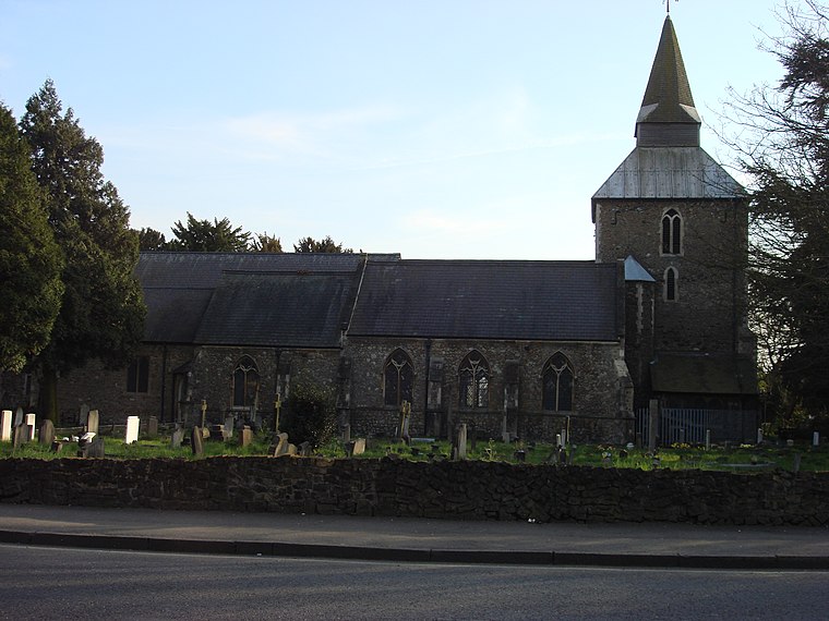
Church of St Laurence, Upminster
Church

Photo: Richard Portsmouth, CC BY-SA 2.0.
The church of St Laurence, Upminster, is the Church of England parish church in Upminster, England. It is a Grade I listed building. It is the historic minster or church from which Upminster derives its name, meaning 'upper church', probably signifying 'church on higher ground'. Church of St Laurence, Upminster is situated 530 feet southwest of Bloomingdoyles.
Upminster Windmill
 Upminster Windmill is a Grade II* listed smock mill located in Upminster in the London Borough of Havering, England. It was formerly known as Abraham's Mill and was in Essex when built. Upminster Windmill is situated 1,100 feet northwest of Bloomingdoyles.
Places in the Area
Nearby places include Upminster and Upminster Bridge.
Upminster
Suburb
 Upminster is a suburb in East London, England, located 16.5 miles northeast of Charing Cross. Part of the London Borough of Havering, it is one of the locally important district centres identified in the London Plan.
Upminster Bridge
Quarter

Photo: MRSC, CC BY-SA 3.0.
Upminster Bridge is a crossing of the River Ingrebourne carrying the A124 road between the suburbs of Hornchurch and Upminster in northeast London, England.
Cranham
Suburb

Photo: John Winfield, CC BY-SA 2.0.
Cranham is a residential area of the London Borough of Havering. It is located 17.5 miles east-northeast of Charing Cross and comprises an extensive built-up area to the north and a low density conservation area to the south surrounded by open land.
Bloomingdoyles
- Type: Retail building
- Category: building
- Location: Havering, Greater London, England, United Kingdom, Britain and Ireland, Europe
- View on OpenStreetMap
Latitude
51.55668° or 51° 33′ 24″ northLongitude
0.24976° or 0° 14′ 59″ eastLevels
2Open location code
9F32H64X+MWOpenStreetMap ID
way 318026130OpenStreetMap feature
building=retail
This page is based on OpenStreetMap, Wikidata, and Wikimedia Commons.
We’d love your help improving our open data sources. Thank you for contributing.
Satellite Map
Discover Bloomingdoyles from above in high-definition satellite imagery.
Notable Places Nearby
Highlights include Upminster Post Office and Trinity United Reformed Church.
Nearby Places
Explore places such as Beresfords and Bairstow Eves.
England: Must-Visit Destinations
Delve into London, Manchester, Sheffield, and Leeds.
Curious Retail Buildings to Discover
Uncover intriguing retail buildings from every corner of the globe.
About Mapcarta. Data © OpenStreetMap contributors and available under the Open Database License". Text is available under the CC BY-SA 4.0 license, except for photos, directions, and the map. Photo: sidibousaid, CC BY 2.0.