Padua War Cemetery
Padua War Cemetery is a cemetery in Padua, Padova, Veneto. Padua War Cemetery is situated nearby to the library Montà Legge, as well as near the public building Sala civica Barison.| Tap on a place to explore it |
Places of Interest Nearby
Highlights include Scrovegni Chapel and Stadio Euganeo.
Scrovegni Chapel
Museum

Photo: Piroddi.andrea, CC BY-SA 3.0.
The Scrovegni Chapel, also known as the Arena Chapel, is a small church, adjacent to the Augustinian monastery, the Monastero degli Eremitani in Padua, region of Veneto, Italy. Scrovegni Chapel is situated 3 km east of Padua War Cemetery.
Stadio Euganeo
Stadium
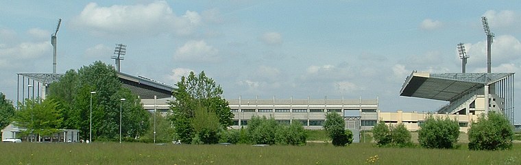
Photo: LigaDue, CC BY-SA 3.0.
Stadio Euganeo is a multipurpose stadium located in Padua, Italy. Primarily used for football, it is also used for athletics events, concerts, rugby league and rugby union matches. Stadio Euganeo is situated 2 km northeast of Padua War Cemetery.
Orto botanico di Padova
Park

Photo: Wikimedia, CC BY-SA 2.5.
The Orto Botanico di Padova is a botanical garden in Padua, in the northeastern part of Italy. Founded in June 1545 by the Venetian Republic, it is the world's oldest academic botanical garden that is still in its original location. Orto botanico di Padova is situated 4 km southeast of Padua War Cemetery.
Places in the Area
Nearby places include Arcella and Altichiero.
Arcella
Suburb
Photo: mauro.puppett photography, CC BY 2.0.
Arcella is the name of a district in Padua, located close to the Milan-Venice railway, north-east of Padua's central station. However, urban expansion taking place since the 1950s, made the boundaries between the localities nearby imperceptible. Arcella is situated 3½ km east of Padua War Cemetery.
Altichiero
Suburb
Photo: Filippof, CC BY-SA 3.0.
Altichiero is a suburb, which is situated 4 km northeast of Padua War Cemetery.
Rubano
Town

Photo: Xaneitaly, CC BY-SA 4.0.
Rubano is a comune in the Province of Padua in the Italian region Veneto, located about 40 kilometres west of Venice and about 7 kilometres northwest of Padua. Rubano is situated 4 km west of Padua War Cemetery.
Padua War Cemetery
- Type: Cemetery
- Categories: Commonwealth War Graves Commission maintained cemetery and burial
- Location: Padua, Padova, Veneto, Northeast Italy, Italy, Europe
- View on OpenStreetMap
Latitude
45.4212° or 45° 25′ 16″ northLongitude
11.84088° or 11° 50′ 27″ eastOpen location code
8FQHCRCR+F9OpenStreetMap ID
way 319745162OpenStreetMap feature
landuse=cemeteryWikidata ID
Q110606365
This page is based on OpenStreetMap, Wikidata, and Wikimedia Commons.
We’d love your help improving our open data sources. Thank you for contributing.
Satellite Map
Discover Padua War Cemetery from above in high-definition satellite imagery.
In Other Languages
“Padua War Cemetery” goes by many names.
- Italian: “Cimitero di Guerra del Commonwealth Padova/Padua War Cemetery”
- Italian: “Padua War Cemetery”
Notable Places Nearby
Highlights include Montà Legge and Sala civica Barison.
Nearby Places
Explore places such as Coislha Bio and Alì.
Veneto: Must-Visit Destinations
Delve into Venice, Verona, Vicenza, and Treviso.
Curious Cemeteries to Discover
Uncover intriguing cemeteries from every corner of the globe.
About Mapcarta. Data © OpenStreetMap contributors and available under the Open Database License". Text is available under the CC BY-SA 4.0 license, except for photos, directions, and the map. Photo: Wikimedia, CC0.