Hunningley Grange
Hunningley Grange is a social service facility in Barnsley, England which is located on Doncaster Road. Hunningley Grange is situated nearby to the sports venue Jonnys gym, as well as near Stairfoot Post Office.| Tap on a place to explore it |
Places of Interest Nearby
Highlights include Oakwell and Monk Bretton Priory.
Oakwell
Stadium
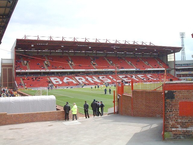
Photo: Martin Thirkettle, CC BY-SA 2.0.
Oakwell is a multi-purpose sports ground in Barnsley, South Yorkshire, England used by Barnsley Football Club for home fixtures, and those of their reserves. Oakwell is situated 1 mile northwest of Hunningley Grange.
Monk Bretton Priory
 Monk Bretton Priory is a ruined medieval priory located in the village of Lundwood, and close to Monk Bretton, South Yorkshire, England. Monk Bretton Priory is situated 3,400 feet north of Hunningley Grange.
Oaks Colliery Disaster Memorial
Memorial

Photo: Badics, CC BY-SA 3.0.
Oaks Colliery Disaster Memorial is situated 2,600 feet west of Hunningley Grange.
Places in the Area
Nearby places include Stairfoot and Ardsley.
Stairfoot
Suburb
Stairfoot is a ward in Barnsley, South Yorkshire, England. It is perhaps so named because it lies at the bottom of a valley in between the undulations of two small hills on the old road from Barnsley to Doncaster.
Ardsley
Village
Ardsley is a small village approximately 3 miles east from Barnsley and forms part of the Metropolitan Borough of Barnsley of South Yorkshire, England.
Hunningley Grange
- Type: Social service facility
- Address: 327 Doncaster Road, Stairfoot, Barnsley, S70 3PJ
- Categories: building and residential building
- Location: Barnsley, England, United Kingdom, Britain and Ireland, Europe
- View on OpenStreetMap
Latitude
53.54542° or 53° 32′ 44″ northLongitude
-1.44372° or 1° 26′ 37″ westOpen location code
9C5WGHW4+5GOpenStreetMap ID
way 332731000OpenStreetMap feature
amenity=social_facilityOpenStreetMap feature
building=residential
This page is based on OpenStreetMap, Wikidata, and Wikimedia Commons.
We’d love your help improving our open data sources. Thank you for contributing.
Satellite Map
Discover Hunningley Grange from above in high-definition satellite imagery.
Notable Places Nearby
Highlights include Jonnys gym and Stairfoot Post Office.
Nearby Places
Explore places such as Doncaster Road/Hunningley Close and Lynton House Dental Practice.
England: Must-Visit Destinations
Delve into London, Manchester, Sheffield, and Leeds.
Curious Social Service Facilities to Discover
Uncover intriguing social service facilities from every corner of the globe.
About Mapcarta. Data © OpenStreetMap contributors and available under the Open Database License". Text is available under the CC BY-SA 4.0 license, except for photos, directions, and the map. Photo: Badics, CC BY-SA 3.0.