Altrincham Kersal Rugby Football Club
Altrincham Kersal Rugby Football Club is a building in Manchester, England. Altrincham Kersal Rugby Football Club is situated nearby to the park Timperley Green, as well as near Timperley Library.| Tap on a place to explore it |
Places of Interest Nearby
Highlights include Sandilands Community Primary School and Church of St John the Divine, Brooklands.
Sandilands Community Primary School
School
This is a list of schools in Manchester, England. In 2010, the Manchester Local Education Authority was ranked last out of Greater Manchester's ten LEAs – and 147th out of 150 in the country LEAs – based on the percentage of pupils attaining at least five A*–C grades at General Certificate of Secondary Education including maths and English. Sandilands Community Primary School is situated 1,300 feet northeast of Altrincham Kersal Rugby Football Club.
Church of St John the Divine, Brooklands
Church
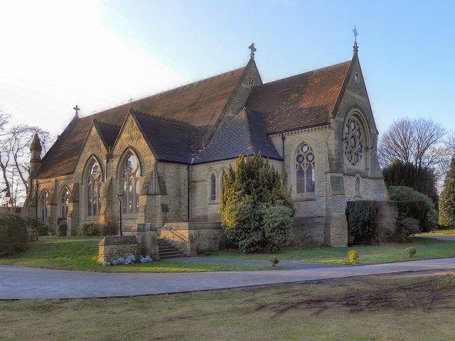
Photo: David Dixon, CC BY-SA 2.0.
The Church of St John the Divine is a Church of England parish church in Brooklands, Sale, Greater Manchester. The church is a grade II* listed building. Church of St John the Divine, Brooklands is situated 3,400 feet northwest of Altrincham Kersal Rugby Football Club.
Christ Church
Church

Photo: Roger May, CC BY-SA 2.0.
Christ Church is situated 3,900 feet south of Altrincham Kersal Rugby Football Club.
Places in the Area
Nearby places include Baguley and Northern Moor.
Baguley
Suburb
 Baguley is an area and electoral ward of the city of Manchester, in Greater Manchester, England. The population at the 2011 census was 14,794. The name Baguley is derived from the Old English words bagga and lēah.
Northern Moor
Suburb
Northern Moor is an area of Manchester, England, north of Baguley, west of Northenden and east of Sale, 5 miles south of Manchester city centre. The Tatton family lived from 1540 to 1926 at Wythenshawe Hall in Northern Moor; land around it is now Wythenshawe Park, which was a deer park from 1200 to 1540.
Newall Green
Suburb
Newall Green is an area in the Wythenshawe district of Manchester, England. It is on the west side of the M56 motorway, approximately 1 mile from Wythenshawe Town Centre. Newall Green is situated 1½ miles southeast of Altrincham Kersal Rugby Football Club.
Altrincham Kersal Rugby Football Club
- Type: Building
- Location: Manchester, England, United Kingdom, Britain and Ireland, Europe
- View on OpenStreetMap
Latitude
53.40067° or 53° 24′ 2″ northLongitude
-2.31231° or 2° 18′ 44″ westOpen location code
9C5VCM2Q+73OpenStreetMap ID
way 385361457OpenStreetMap feature
building=yes
This page is based on OpenStreetMap, Wikidata, and Wikimedia Commons.
We’d love your help improving our open data sources. Thank you for contributing.
Satellite Map
Discover Altrincham Kersal Rugby Football Club from above in high-definition satellite imagery.
Notable Places Nearby
Highlights include Altrincham Kersal Rugby Football Club and Timperley Green.
Nearby Places
Explore places such as Timperley, Stockport Road / near Stelfox Avenue and Timperley, Stockport Road / opposite Stelfox Avenue.
Manchester: Must-Visit Destinations
Delve into Manchester Airport, Victoria-Shopping District, Piccadilly-East Centre, and Castlefield-Petersfield.
Curious Buildings to Discover
Uncover intriguing buildings from every corner of the globe.
About Mapcarta. Data © OpenStreetMap contributors and available under the Open Database License". Text is available under the CC BY-SA 4.0 license, except for photos, directions, and the map. Photo: David Dixon, CC BY-SA 2.0.