Diamanthotel
Diamanthotel is a hotel in Idar-Oberstein, Birkenfeld, Rhineland-Palatinate which is located on Tiefensteiner Straße. Diamanthotel is situated nearby to the fire station Freiwillige Feuerwehr Idar-Oberstein - Wache 2, as well as near the cemetery Hohenau.| Tap on a place to explore it |
- Email: welcome@diamanthotel.de
- Type: Hotel
- Cuisine: regional
- Address: Tiefensteiner Straße 235, Idar-Oberstein, 55743
- Wheelchair access: yes
Places of Interest Nearby
Highlights include Stadion Im Haag and Deutsches Edelsteinmuseum.
Stadion Im Haag
Pitch
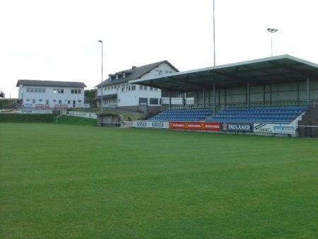
Photo: Rkal, CC BY-SA 3.0.
Stadion Im Haag is a pitch, which is situated 1 km east of Diamanthotel.
Deutsches Edelsteinmuseum
Museum

Photo: Wikimedia, CC BY-SA 3.0.
Deutsches Edelsteinmuseum is situated 3 km southeast of Diamanthotel.
Gymnasium an der Heinzenwies
School

Photo: Wikimedia, CC BY-SA 2.5.
Gymnasium an der Heinzenwies is a school, which is situated 3 km southeast of Diamanthotel.
Places in the Area
Nearby places include Vollmersbach and Hettenrodt.
Vollmersbach
Village
Vollmersbach is an Ortsgemeinde – a municipality belonging to a Verbandsgemeinde, a kind of collective municipality – in the Birkenfeld district in Rhineland-Palatinate, Germany. It belongs to the Verbandsgemeinde Herrstein-Rhaunen, whose seat is in Herrstein.
Hettenrodt
Village
 Hettenrodt is an Ortsgemeinde – a municipality belonging to a Verbandsgemeinde, a kind of collective municipality – in the Birkenfeld district in Rhineland-Palatinate, Germany. It belongs to the Verbandsgemeinde Herrstein-Rhaunen, whose seat is in Herrstein.
Veitsrodt
Village

Photo: AK-Bino, CC BY-SA 4.0.
Veitsrodt is an Ortsgemeinde – a municipality belonging to a Verbandsgemeinde, a kind of collective municipality – in the Birkenfeld district in Rhineland-Palatinate, Germany. It belongs to the Verbandsgemeinde Herrstein-Rhaunen, whose seat is in Herrstein.
Diamanthotel
- Categories: restaurant, building, tourism, and accommodation
- Location: Idar-Oberstein, Birkenfeld, Hunsrück, Rhineland-Palatinate, Germany, Central Europe, Europe
- View on OpenStreetMap
Latitude
49.73863° or 49° 44′ 19″ northLongitude
7.28123° or 7° 16′ 52″ eastOpen location code
8FX9P7QJ+FFOpenStreetMap ID
way 387007245OpenStreetMap feature
amenity=restaurantOpenStreetMap feature
building=yesOpenStreetMap feature
tourism=hotelOpenStreetMap attribute
cuisine=regionalOpenStreetMap attribute
wheelchair=yes
This page is based on OpenStreetMap, Wikidata, and Wikimedia Commons.
We’d love your help improving our open data sources. Thank you for contributing.
Satellite Map
Discover Diamanthotel from above in high-definition satellite imagery.
Places with the Same Name
Discover other places named “Diamanthotel”.
Notable Places Nearby
Highlights include Freiwillige Feuerwehr Idar-Oberstein - Wache 2 and Hohenau.
Nearby Places
Explore places such as Tiefenstein, Andreasstraße and Pension Seibel.
Rhineland-Palatinate: Must-Visit Destinations
Delve into Mainz, Trier, Koblenz, and Worms.
Curious Hotels to Discover
Uncover intriguing hotels from every corner of the globe.
About Mapcarta. Data © OpenStreetMap contributors and available under the Open Database License". Text is available under the CC BY-SA 4.0 license, except for photos, directions, and the map. Photo: W. Bulach, CC BY-SA 4.0.