St John’s Catholic Primary School
St John’s Catholic Primary School is a school in Bath and North East Somerset, England which is located on Oldfield Lane. St John’s Catholic Primary School is situated nearby to Linear Park, as well as near Church of Our Lady & St Alphege, Bath.| Tap on a place to explore it |
- Type: School
- Denomination: Roman Catholic
- Description: school in Bath and North East Somerset, UK
- Address: Oldfield Lane, Bath, BA2 3NR
Places of Interest Nearby
Highlights include Church of Our Lady & St Alphege, Bath and St Barts.
Church of Our Lady & St Alphege, Bath
Church

Photo: Jaggery, CC BY-SA 2.0.
The Church of Our Lady & St Alphege is a Roman Catholic church located in the Oldfield Park suburb of Bath, Somerset. The church was built between 1927 and 1929 to the designs of Sir Giles Gilbert Scott, the architect of Liverpool Cathedral.
St Barts
Church

Photo: Bill Boaden, CC BY-SA 2.0.
St Barts is a church, which is situated 820 feet north of St John’s Catholic Primary School.
Roman Baths
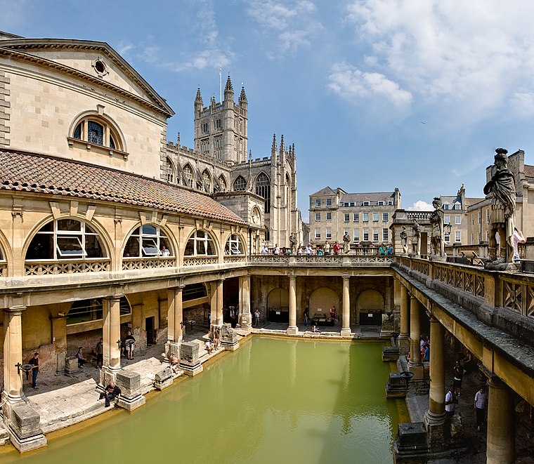 The Roman Baths are well-preserved thermae in the city of Bath, Somerset, England. A temple was constructed on the site between 60 and 70 AD in the first few decades of Roman Britain. Roman Baths is situated 1 mile northeast of St John’s Catholic Primary School.
Places in the Area
Nearby places include Bear Flat and Lyncombe.
Bear Flat
Suburb

Photo: Rwendland, CC BY-SA 3.0.
Bear Flat is a neighbourhood within the city of Bath, Somerset, England, to the south of the city centre and to the west of Beechen Cliff. It forms the southern part of the Widcombe and Lyncombe electoral ward.
Lyncombe
Suburb

Photo: Derek Harper, CC BY-SA 2.0.
Lyncombe is a district and electoral ward in Bath, Somerset, and a former parish in the Diocese of Bath and Wells. In the mid-19th century the parish was formed when the parish of Widcombe and Lyncombe was split in two, but it was abolished in the late 1960s.
Bath
 Bath is a historic Roman and Georgian spa city. It is famous for its hot springs, Roman period baths, Medieval heritage and stately Georgian architecture.
St John’s Catholic Primary School
- Categories: voluntary aided school, primary school, and education
- Location: Bath and North East Somerset, England, United Kingdom, Britain and Ireland, Europe
- View on OpenStreetMap
Latitude
51.37297° or 51° 22′ 23″ northLongitude
-2.3752° or 2° 22′ 31″ westOpen location code
9C3V9JFF+5WOpenStreetMap ID
way 42431732OpenStreetMap feature
amenity=schoolOpenStreetMap attribute
denomination=roman_catholicWikidata ID
Q67148180
This page is based on OpenStreetMap, Wikidata, and Wikimedia Commons.
We’d love your help improving our open data sources. Thank you for contributing.
Satellite Map
Discover St John’s Catholic Primary School from above in high-definition satellite imagery.
Places with the Same Name
Discover other places named “St John’s Catholic Primary School”.
Notable Places Nearby
Highlights include Linear Park and The Moorfields Inn.
Nearby Places
Explore places such as Hillside and Willow Green.
England: Must-Visit Destinations
Delve into London, Manchester, Sheffield, and Leeds.
Curious Places to Discover
Uncover intriguing places from every corner of the globe.
About Mapcarta. Data © OpenStreetMap contributors and available under the Open Database License". Text is available under the CC BY-SA 4.0 license, except for photos, directions, and the map. Photo: sidibousaid, CC BY 2.0.