St Mary’s and St John’s CofE School
St Mary’s and St John’s CofE School is a school in Barnet, Greater London, England which is located on Sunningfields Road. St Mary’s and St John’s CofE School is situated nearby to BMI Hendon Hospital, as well as near the church Hendon St Mary.| Tap on a place to explore it |
- Type: School
- Denomination: Anglican
- Address: Sunningfields Road, London, NW4 4QR
Places of Interest Nearby
Highlights include Sunny Hill Park and Royal Air Force Museum London.
Sunny Hill Park
Park

Photo: Dudley Miles, Public domain.
Sunny Hill Park is a park in Hendon, in the London Borough of Barnet, England. It is a large hilly park, 22 hectares, mainly grassed, which has extensive views to the north and the west. Sunny Hill Park is situated 1,900 feet northwest of St Mary’s and St John’s CofE School.
Royal Air Force Museum London
Museum
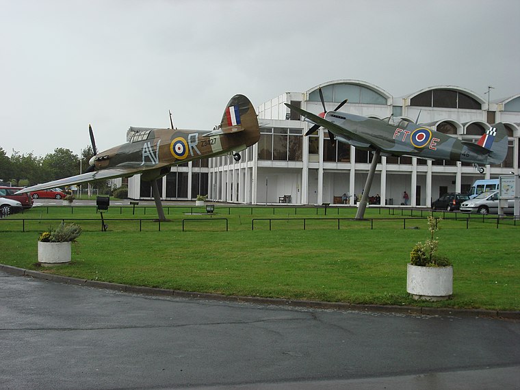 The Royal Air Force Museum London is located on the former Hendon Aerodrome, in North London's Borough of Barnet. It includes five buildings and hangars showing the history of aviation and the Royal Air Force. Royal Air Force Museum London is situated 4,200 feet northwest of St Mary’s and St John’s CofE School.
Hendon Library
Library

Photo: R Sones, CC BY-SA 2.0.
Hendon Library is situated 1,900 feet southwest of St Mary’s and St John’s CofE School.
Places in the Area
Nearby places include Hendon and The Hyde.
Hendon
Suburb

Photo: Steve Cadman, CC BY-SA 2.0.
Hendon is an urban area in the London Borough of Barnet, northwest London 7 miles northwest of Charing Cross. Hendon was an ancient manor and parish in the county of Middlesex and a former borough, the Municipal Borough of Hendon; it has been part of Greater London since 1965.
The Hyde
Quarter
The Hyde is a locality in the London Borough of Barnet in London, England, and is also the name of its accompanying main road on the A5. It is located to the east of Kingsbury, west of Hendon and south of Colindale.
Brent Cross
Suburb
Photo: BillyH, CC BY-SA 3.0.
Brent Cross is a major traffic interchange and area in the London Borough of Barnet, England. Originally the name of a crossroads, it is located a mile from the centres of Hendon and Golders Green.
St Mary’s and St John’s CofE School
- Category: education
- Location: Barnet, Greater London, England, United Kingdom, Britain and Ireland, Europe
- View on OpenStreetMap
Latitude
51.5922° or 51° 35′ 32″ northLongitude
-0.22296° or 0° 13′ 23″ westOpen location code
9C3XHQRG+VROpenStreetMap ID
way 450841761OpenStreetMap feature
amenity=schoolOpenStreetMap attribute
denomination=anglican
This page is based on OpenStreetMap, Wikidata, and Wikimedia Commons.
We’d love your help improving our open data sources. Thank you for contributing.
Satellite Map
Discover St Mary’s and St John’s CofE School from above in high-definition satellite imagery.
Places with the Same Name
Discover other places named “St Mary’s and St John’s CofE School”.
Notable Places Nearby
Highlights include BMI Hendon Hospital and Hendon St Mary.
Nearby Places
Explore places such as Downage and BMI Hendon Hospital.
England: Must-Visit Destinations
Delve into London, Manchester, Sheffield, and Leeds.
Curious Schools to Discover
Uncover intriguing schools from every corner of the globe.
About Mapcarta. Data © OpenStreetMap contributors and available under the Open Database License". Text is available under the CC BY-SA 4.0 license, except for photos, directions, and the map. Photo: sidibousaid, CC BY 2.0.