Hogesluis
Hogesluis is a bridge in Government of Amsterdam, North Holland. Hogesluis is situated nearby to the hotel InterContinental Amstel Amsterdam, as well as near the work of art De jonge Rembrandt.| Tap on a place to explore it |
- Type: Bridge
- Description: bridge in Amsterdam, Netherlands
- Also known as: “Amstelbrug”, “Bridge 246”, “Hoge Sluis”, and “MVDP-brug”
Places of Interest Nearby
Highlights include Canal District and Magere Brug.
Canal District

Photo: Massimo Catarinella, CC BY-SA 3.0.
The Canal District is the famous 17th-century district surrounding the Binnenstad of Amsterdam. The whole district is designated as a UNESCO World Heritage Site for its unique cultural and historical value, and its property values are among the highest in the country.
Magere Brug

Photo: S Sepp, CC BY-SA 3.0.
The Magere Brug is a bridge over the river Amstel in Amsterdam, Netherlands. It connects the banks of the river at Kerkstraat, between the Keizersgracht and Prinsengracht. Magere Brug is situated 380 metres north of Hogesluis.
Rijksmuseum Amsterdam
Museum

Photo: Nikolai Karaneschev, CC BY 3.0.
The Rijksmuseum is the national museum of the Netherlands dedicated to Dutch arts and history and is located in Amsterdam. The museum is located at the Museum Square in the borough of Amsterdam South, close to the Van Gogh Museum, the Stedelijk Museum Amsterdam, and the Royal Concertgebouw. Rijksmuseum Amsterdam is situated 1¼ km west of Hogesluis.
Places in the Area
Nearby places include Oude Pijp and Plantage.
Oude Pijp
Neighborhood

Photo: Ceinturion, CC BY-SA 3.0.
Oude Pijp, also known as Noord-Pijp is a neighbourhood of Amsterdam, Netherlands located in an urbanised part of the Zuid borough. It had a population of 14,102 in 2011 and an area of 68 hectares.
Plantage

Photo: Zxempire, CC BY-SA 3.0 nl.
Plantage is a leafy neighbourhood in the centre of Amsterdam. This article also covers the Eastern Islands.
Amsterdam-Centrum
Suburb
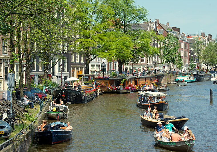
Photo: kevinmcgill, CC BY-SA 2.0.
Amsterdam-Centrum is the inner-most borough and historical city centre of Amsterdam, Netherlands, containing the majority of the city's landmarks. Established in 2002, Amsterdam-Centrum was the last area in the city to be granted the status of self-governing borough.
Hogesluis
- Category: transportation
- Location: Government of Amsterdam, North Holland, Western Netherlands, Netherlands, Benelux, Europe
- View on OpenStreetMap
Latitude
52.36035° or 52° 21′ 37″ northLongitude
4.90401° or 4° 54′ 14″ eastOpen location code
9F469W63+4JOpenStreetMap ID
way 457712803OpenStreetMap feature
man_made=bridgeWikidata ID
Q2091548
This page is based on OpenStreetMap, Wikidata, and Wikimedia Commons.
We’d love your help improving our open data sources. Thank you for contributing.
Satellite Map
Discover Hogesluis from above in high-definition satellite imagery.
In Other Languages
From Afrikaans to Swedish—“Hogesluis” goes by many names.
- Afrikaans: “Brug 246”
- Afrikaans: “Hogesluis”
- Breton: “Hogesluis”
- Breton: “Pont 246”
- Czech: “Hogesluis”
- Czech: “Most 246”
- Danish: “Bro 246”
- Danish: “Hogesluis”
- Dutch: “Brug 246”
- Dutch: “Hogesluis”
- Dutch: “rijksmonumentnummer 518386”
- French: “Hogesluis”
- French: “Pont 246”
- German: “Brücke 246”
- German: “Hogesluis”
- Indonesian: “Hogesluis”
- Indonesian: “Jembatan 246”
- Italian: “Hogesluis”
- Italian: “Ponte 246”
- Limburgan: “Brögk 246”
- Limburgan: “Hogesluis”
- Swedish: “Bro 246”
- Swedish: “Hogesluis”
Notable Places Nearby
Highlights include InterContinental Amstel Amsterdam and De jonge Rembrandt.
Nearby Places
Explore places such as houseboat Rose and McKinsey & Company.
North Holland: Must-Visit Destinations
Delve into Amsterdam, Haarlem, Alkmaar, and Schiphol Airport.
Curious Bridges to Discover
Uncover intriguing bridges from every corner of the globe.
About Mapcarta. Data © OpenStreetMap contributors and available under the Open Database License". Text is available under the CC BY-SA 4.0 license, except for photos, directions, and the map. Photo: Arch, Public domain.