Black Country Millennium Forest
Black Country Millennium Forest is a forest in Wolverhampton, England. Black Country Millennium Forest is situated nearby to the locality Wobaston, as well as near the suburb Pendeford.| Tap on a place to explore it |
Places of Interest
Highlights include Moseley Old Hall and Molineux Stadium.
Moseley Old Hall

Photo: Mike Peel, CC BY-SA 4.0.
Moseley Old Hall is located in Fordhouses, north of Wolverhampton in the United Kingdom. It is notable as one of the hiding places of Charles II during his escape to France following defeat at the Battle of Worcester in 1651.
Molineux Stadium
Stadium

Photo: John Nickolls, CC BY-SA 2.0.
Molineux Stadium is a football stadium situated in Wolverhampton, West Midlands, England. It has been the home ground of Premier League club Wolverhampton Wanderers since 1889.
Bilbrook railway station
Railway station
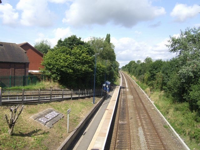
Photo: John M, CC BY-SA 2.0.
Bilbrook railway station is a railway station which serves the village of Bilbrook in Staffordshire, England. It was known as Birches and Bilbrook Halt when opened, being renamed to Bilbrook on 6 May 1974.
Places in the Area
Nearby places include Wednesfield and Codsall.
Wednesfield
Town

Photo: John M, CC BY-SA 2.0.
Wednesfield is a town and historic village in the City of Wolverhampton, in the county of the West Midlands, England; it was historically within the county of Staffordshire.
Codsall
Village
Photo: John M, CC BY-SA 2.0.
Codsall is a village and civil parish in the South Staffordshire district of Staffordshire, England. It is situated 5 miles northwest of Wolverhampton and 13 miles east-southeast of Telford.
Featherstone
Village

Photo: John M, CC BY-SA 2.0.
Featherstone is a village in the district of South Staffordshire in Staffordshire England. It is near to the border with Wolverhampton.
Black Country Millennium Forest
- Type: Forest
- Location: Wolverhampton, England, United Kingdom, Britain and Ireland, Europe
- View on OpenStreetMap
Latitude
52.628° or 52° 37′ 41″ northLongitude
-2.1377° or 2° 8′ 16″ westOpen location code
9C4VJVH6+5WOpenStreetMap ID
way 459410081OpenStreetMap feature
natural=wood
This page is based on OpenStreetMap, Wikidata, and Wikimedia Commons.
We’d love your help improving our open data sources. Thank you for contributing.
Satellite Map
Discover Black Country Millennium Forest from above in high-definition satellite imagery.
Places with the Same Name
Discover other places named “Black Country Millennium Forest”.
Localities in the Area
Explore places such as Wobaston and Pendeford.
Notable Places Nearby
Highlights include Black Country Millennium Forest and Fordhouses Cricket Club.
England: Must-Visit Destinations
Delve into London, Manchester, Sheffield, and Leeds.
Curious Forests to Discover
Uncover intriguing forests from every corner of the globe.
About Mapcarta. Data © OpenStreetMap contributors and available under the Open Database License". Text is available under the CC BY-SA 4.0 license, except for photos, directions, and the map. Photo: Mariegriffiths, CC BY-SA 4.0.