ایرنا
ایرنا is in Qazvin Province, Iran. ایرنا is situated nearby to the bus station ایستگاه اتوبوسرانی, as well as near Valiasr Mosque.| Tap on a place to explore it |
Places of Interest Nearby
Highlights include Kantour Church and Carevansara Sa’do Saltaneh.
Kantour Church

Photo: Kourosh-kahal, CC BY-SA 4.0.
Cantor Church is a Russian Orthodox church in Qazvin, Iran. Kantour Church is situated 740 metres northwest of ایرنا.
Carevansara Sa’do Saltaneh
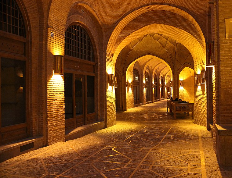
Photo: Fereshteh Sa, CC BY-SA 4.0.
The Sa'd al-Saltaneh Caravanserai is a large Caravanserai located in the city of Qazvin, Qazvin province, Iran. Built during the Qajar era, the caravanserai is one of Iran's best preserved urban caravanserais, and the world's largest indoor caravanserai. Carevansara Sa’do Saltaneh is situated 1½ km west of ایرنا.
Grand Hotel
Museum

Photo: Arpourabedin, CC BY-SA 4.0.
The Grand Hotel, Qazvin was a Qajar era hotel built in 1922, and under the governorship of Sa'd as-Saltaneh, in Qazvin, Iran. It was built in the western wing of Chehel Sotun Palace, by the well-known architect of Qazvin, Ostad Ali July. Grand Hotel is situated 1¼ km west of ایرنا.
Places in the Area
Nearby places include Qazvin and Kheyrabad.
Qazvin

Photo: Omid hendupur, CC BY-SA 3.0.
Qazvin is a city in the Central District of Qazvin County, Qazvin province, Iran, serving as capital of the province, the county, and the district. It is the largest city in the province.
Kheyrabad
Village
Kheyrabad is a neighborhood in the city of Qazvin in the Central District of Qazvin County, Qazvin province, Iran. Kheyrabad is situated 6 km southwest of ایرنا.
Chubin Dar
Town
Chubin Dar is a neighborhood in the city of Qazvin in the Central District of Qazvin County, Qazvin province, Iran. Chubin Dar is situated 7 km southwest of ایرنا.
ایرنا
- Type: Commerce
- Location: Qazvin Province, Iran, Middle East, Asia
- View on OpenStreetMap
Latitude
36.26525° or 36° 15′ 55″ northLongitude
50.0167° or 50° 1′ 0″ eastOpen location code
8H8G7288+4MOpenStreetMap ID
way 486169619OpenStreetMap feature
landuse=commercial
This page is based on OpenStreetMap, Wikidata, and Wikimedia Commons.
We’d love your help improving our open data sources. Thank you for contributing.
Satellite Map
Discover ایرنا from above in high-definition satellite imagery.
Places with the Same Name
Discover other places named “ایرنا”.
Notable Places Nearby
Highlights include ایستگاه اتوبوسرانی and Valiasr Mosque.
Nearby Places
Explore places such as IRNA and Bank Melli Iran.
Iran: Must-Visit Destinations
Delve into Tehran, Isfahan, Tabriz, and Sistan and Baluchestan.
Curious Places to Discover
Uncover intriguing places from every corner of the globe.
About Mapcarta. Data © OpenStreetMap contributors and available under the Open Database License". Text is available under the CC BY-SA 4.0 license, except for photos, directions, and the map. Photo: Wikimedia, CC0.