Parking de la Chataigneraie
Parking de la Chataigneraie is a parking area in Plaisir, Arrondissement of Versailles, Île-de-France. Parking de la Chataigneraie is situated nearby to the forest Parc du Château, as well as near the shopping center Centre commercial Pasteur.| Tap on a place to explore it |
Places of Interest Nearby
Highlights include Château de Plaisir and Église Saint-Pierre de Plaisir (Yvelines).
Château de Plaisir
Castle

Photo: Wikimedia, CC BY-SA 3.0.
Château de Plaisir is a castle, which is situated 1 km northeast of Parking de la Chataigneraie.
Église Saint-Pierre de Plaisir (Yvelines)
Church

Photo: Peter17, CC BY-SA 4.0.
Église Saint-Pierre de Plaisir (Yvelines) is a church, which is situated 790 metres northeast of Parking de la Chataigneraie.
Colline d’Élancourt
Scenic viewpoint

Photo: Rémih, CC BY-SA 4.0.
Colline d'Élancourt, previously known Colline de la Revanche, is a hill located in Élancourt in the French department of Yvelines. With a height of 231 meters above sea level, it is the highest point in Yvelines and Île-de-France. Colline d’Élancourt is situated 3 km southeast of Parking de la Chataigneraie.
Places in the Area
Nearby places include Neauphle-le-Château and Jouars-Pontchartrain.
Neauphle-le-Château
Village
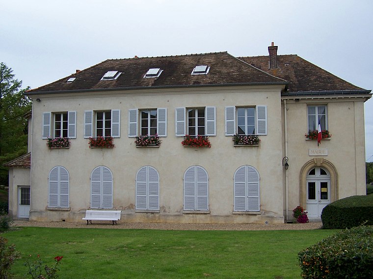
Photo: Henrysalome, CC BY-SA 3.0.
Neauphle-le-Château is a commune in the Yvelines department in the Île-de-France region in north-central France. Neauphle-le-Château is situated 3 km west of Parking de la Chataigneraie.
Jouars-Pontchartrain
Village

Photo: Henrysalome, CC BY-SA 3.0.
Jouars-Pontchartrain is a commune in the Yvelines department in the Île-de-France region in north-central France. It is approximately 35 kilometres from Paris. This city is famous for the Château de Pontchartrain. Jouars-Pontchartrain is situated 3½ km west of Parking de la Chataigneraie.
Les Clayes-sous-Bois
Town

Photo: Polymagou, CC BY-SA 4.0.
Les Clayes-sous-Bois is a commune in the Yvelines department in the Île-de-France region in north-central France. It is located in the western suburbs of Paris 26.7 km from the center. The Clayes-sous-Bois inhabitants are called "Clétiens". Les Clayes-sous-Bois is situated 3½ km east of Parking de la Chataigneraie.
Parking de la Chataigneraie
- Type: Parking area
- Parking: surface
- Category: transportation
- Location: Plaisir, Arrondissement of Versailles, Yvelines, Île-de-France, France, Europe
- View on OpenStreetMap
Latitude
48.81051° or 48° 48′ 38″ northLongitude
1.94313° or 1° 56′ 35″ eastOpen location code
8FW3RW6V+67OpenStreetMap ID
way 518424326OpenStreetMap feature
amenity=parkingOpenStreetMap attribute
parking=surface
This page is based on OpenStreetMap, Wikidata, and Wikimedia Commons.
We’d love your help improving our open data sources. Thank you for contributing.
Satellite Map
Discover Parking de la Chataigneraie from above in high-definition satellite imagery.
Notable Places Nearby
Highlights include Parc du Château and Centre commercial Pasteur.
Nearby Places
Explore places such as Jean-Jacques Rousseau and Châtaigneraie.
Île-de-France: Must-Visit Destinations
Delve into Paris, Versailles, Boulogne-Billancourt, and Paris Charles de Gaulle Airport.
Curious Parking Areas to Discover
Uncover intriguing parking areas from every corner of the globe.
About Mapcarta. Data © OpenStreetMap contributors and available under the Open Database License". Text is available under the CC BY-SA 4.0 license, except for photos, directions, and the map. Photo: Inkey, CC BY-SA 3.0.