Kruft Kf
Kruft Kf is a building in Kruft, Mayen-Koblenz, Rhineland-Palatinate. Kruft Kf is situated nearby to the fire station Gerätehaus Freiwillige Feuerwehr Kruft, as well as near the church St. Dionysius.| Tap on a place to explore it |
Places of Interest Nearby
Highlights include Meurin Roman mine and Korretsberg.
Meurin Roman mine
Archaeological site

Photo: Schaengel, CC BY-SA 3.0 de.
The Volcano Park in Mayen-Koblenz is a geopark in the rural district of Mayen-Koblenz in the eastern Vulkan Eifel, Germany. It was founded in 1996 and wraps around the Laacher See. Meurin Roman mine is situated 1½ km northeast of Kruft Kf.

Mendig Air Base
Aerodrome
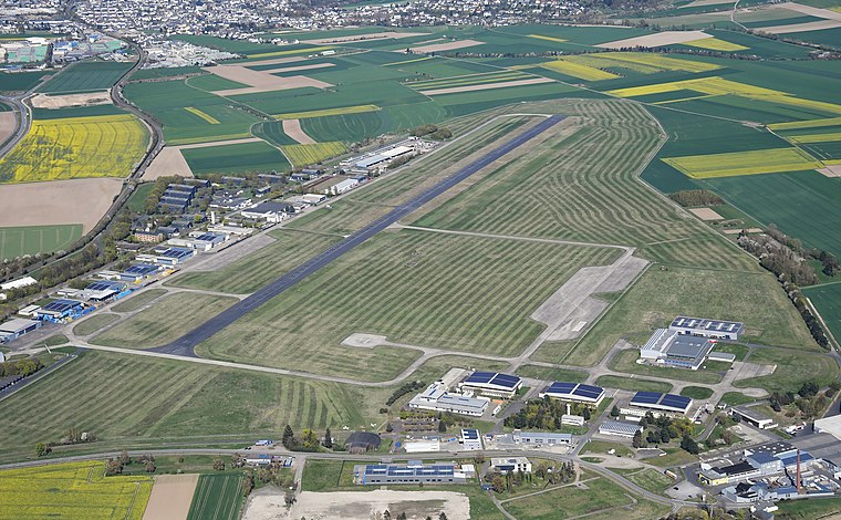
Photo: Carsten Steger, CC BY-SA 4.0.
Mendig Air Base is a former military air base located southeast of the city of Mendig, Rhineland-Palatinate, Germany. It was home of German Army Medium Transport Helicopter Regiment 35, equipped with CH-53D helicopters. Mendig Air Base is situated 3 km southwest of Kruft Kf.
Places in the Area
Nearby places include Kretz and Nickenich.
Kretz
Village

Photo: LigaDue, CC BY-SA 4.0.
Kretz is a municipality in the district of Mayen-Koblenz in Rhineland-Palatinate, western Germany.
Nickenich
Village

Photo: Xocolatl, Public domain.
Nickenich is a municipality in the district of Mayen-Koblenz in Rhineland-Palatinate, western Germany. Nickenich is situated 2½ km north of Kruft Kf.
Plaidt
Village

Photo: ChillingGrizzly, CC BY-SA 3.0.
Plaidt is a municipality in the district of Mayen-Koblenz in Rhineland-Palatinate, western Germany. It is seat of the Verbandsgemeinde Pellenz since 2017. Plaidt is situated south of Andernach. Plaidt is situated 4 km east of Kruft Kf.
Kruft Kf
- Type: Building
- Location: Kruft, Mayen-Koblenz, Rhineland-Palatinate, Germany, Central Europe, Europe
- View on OpenStreetMap
Latitude
50.38904° or 50° 23′ 21″ northLongitude
7.33592° or 7° 20′ 9″ eastOpen location code
9F2998QP+J9OpenStreetMap ID
way 525020054OpenStreetMap feature
building=yesOpenStreetMap feature
railway=signal_box
This page is based on OpenStreetMap, Wikidata, and Wikimedia Commons.
We’d love your help improving our open data sources. Thank you for contributing.
Satellite Map
Discover Kruft Kf from above in high-definition satellite imagery.
Notable Places Nearby
Highlights include Gerätehaus Freiwillige Feuerwehr Kruft and Kruft.
Nearby Places
Explore places such as Ristaurante Pizzeria Roma and Grundschule A.
Rhineland-Palatinate: Must-Visit Destinations
Delve into Mainz, Trier, Koblenz, and Worms.
Curious Buildings to Discover
Uncover intriguing buildings from every corner of the globe.
About Mapcarta. Data © OpenStreetMap contributors and available under the Open Database License". Text is available under the CC BY-SA 4.0 license, except for photos, directions, and the map. Photo: Traveler100, CC BY-SA 3.0.