Schlehenhof - Hofladen
Schlehenhof - Hofladen is a farm shop in Kruft, Mayen-Koblenz, Rhineland-Palatinate which is located on Schlehenhof. Schlehenhof - Hofladen is situated nearby to the government office Straßenmeisterei Kruft, as well as near the aerodrome Mendig Air Base.| Tap on a place to explore it |
- Opening hours:
Thursday: 8:30 AM—noon
Friday: 8:30 AM—noon and 3:00 PM—6:00 PM
Saturday: 8:30 AM—noon - Type: Farm shop
- Address: Schlehenhof 1, Kruft, 56642
Places of Interest Nearby
Highlights include Mendig Air Base and Lava-Dome Mendig.
Mendig Air Base
Aerodrome
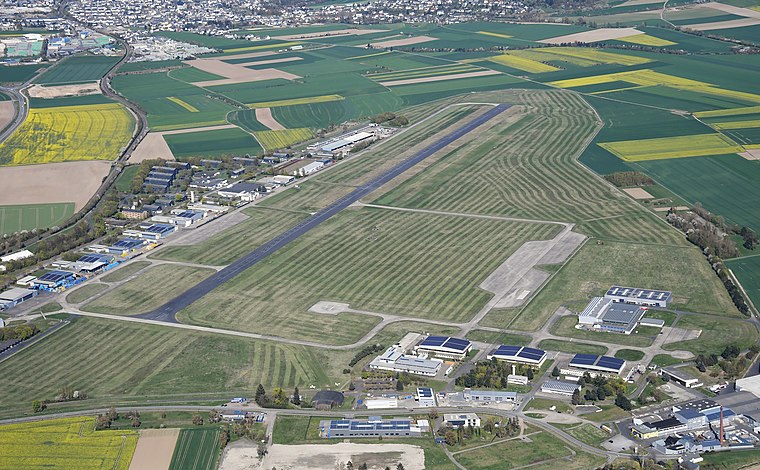
Photo: Carsten Steger, CC BY-SA 4.0.
Mendig Air Base is a former military air base located southeast of the city of Mendig, Rhineland-Palatinate, Germany. It was home of German Army Medium Transport Helicopter Regiment 35, equipped with CH-53D helicopters.
Lava-Dome Mendig
Museum

Photo: Schaengel, CC BY-SA 3.0 de.
Lava-Dome Mendig is a museum, which is situated 3 km west of Schlehenhof - Hofladen.
Meurin Roman mine
Archaeological site

Photo: Schaengel, CC BY-SA 3.0 de.
The Volcano Park in Mayen-Koblenz is a geopark in the rural district of Mayen-Koblenz in the eastern Vulkan Eifel, Germany. It was founded in 1996 and wraps around the Laacher See. Meurin Roman mine is situated 2½ km northeast of Schlehenhof - Hofladen.
Places in the Area
Nearby places include Kretz and Mendig.
Kretz
Village

Photo: LigaDue, CC BY-SA 4.0.
Kretz is a municipality in the district of Mayen-Koblenz in Rhineland-Palatinate, western Germany. Kretz is situated 3 km northeast of Schlehenhof - Hofladen.
Mendig
Town

Photo: Wolkenkratzer, CC BY-SA 4.0.
Mendig is a small town in the district Mayen-Koblenz, in Rhineland-Palatinate, Germany. It is situated approximately 6 km north-east of Mayen, and 25 km west of Koblenz. Mendig is situated 3 km west of Schlehenhof - Hofladen.
Fraukirch
Hamlet

Photo: Mattis, CC BY-SA 3.0.
Fraukirch is a hamlet, which is situated 3½ km south of Schlehenhof - Hofladen.
Schlehenhof - Hofladen
- Categories: building, shop, and food
- Location: Kruft, Mayen-Koblenz, Rhineland-Palatinate, Germany, Central Europe, Europe
- View on OpenStreetMap
Latitude
50.3807° or 50° 22′ 51″ northLongitude
7.32366° or 7° 19′ 25″ eastOpen location code
9F2998JF+7FOpenStreetMap ID
way 525027127OpenStreetMap feature
building=yesOpenStreetMap feature
shop=farm
This page is based on OpenStreetMap, Wikidata, and Wikimedia Commons.
We’d love your help improving our open data sources. Thank you for contributing.
Satellite Map
Discover Schlehenhof - Hofladen from above in high-definition satellite imagery.
Notable Places Nearby
Highlights include Straßenmeisterei Kruft and St. Dionysius.
Nearby Places
Explore places such as Schlehenhof and Hofladen - Katharinenhof.
Rhineland-Palatinate: Must-Visit Destinations
Delve into Mainz, Trier, Koblenz, and Worms.
Curious Farm Shops to Discover
Uncover intriguing farm shops from every corner of the globe.
About Mapcarta. Data © OpenStreetMap contributors and available under the Open Database License". Text is available under the CC BY-SA 4.0 license, except for photos, directions, and the map. Photo: Traveler100, CC BY-SA 3.0.