Sunny Days
Sunny Days is a day care in Santa Clara County, California. Sunny Days is situated nearby to the bridge Hedding Street Undercrossing, as well as near Bascom Avenue Undercrossing.| Tap on a place to explore it |
Places of Interest Nearby
Highlights include O’Connor Hospital and Westfield Valley Fair.
O’Connor Hospital
Hospital
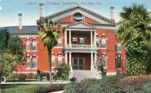 O'Connor Hospital is a hospital in San Jose, California, part of the Santa Clara County Health System. Located in the West San Carlos neighborhood of San Jose, O'Connor Hospital is one of the oldest hospitals in Santa Clara County, founded in 1889. O’Connor Hospital is situated 1,800 feet southeast of Sunny Days.
Westfield Valley Fair
Shopping center
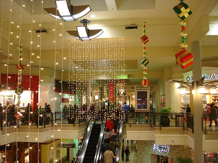
Photo: BrendelSignature, CC BY-SA 3.0.
Westfield Valley Fair, commonly known as Valley Fair, is a prominent shopping mall in San Jose, California. Valley Fair is the largest mall, by area, in Northern California and has higher sales revenue than all other malls in California, including the two in Southern California which have larger area than Valley Fair. Westfield Valley Fair is situated 2,700 feet southwest of Sunny Days.
San Jose Municipal Rose Garden
Park
 The San Jose Municipal Rose Garden is a historic rose garden in San Jose, California, in the Rose Garden District. Founded in 1927, the garden is exclusively dedicated to roses and features more than 3,500 shrubs representing 189 rose varieties.
Places in the Area
Nearby places include Rose Garden and College Park.
Rose Garden
Suburb

Photo: Oleg Alexandrov, CC BY-SA 3.0.
Rose Garden, also rendered as Rosegarden, is a historic district of Central San Jose, California, near Downtown San Jose and The Alameda. Rose Garden is a district made up of numerous historic neighborhoods, such as Hanchett Park, primarily characterized…
College Park
Neighborhood

Photo: David Sawyer, CC BY-SA 2.0.
College Park is a historic neighborhood of Central San Jose, California, located within the greater district of The Alameda.
Buena Vista
Suburb
Buena Vista is a former census-designated place in Santa Clara County, California, United States. The population was 1,704 at the 2000 census. The area is now part of the city of San Jose. Buena Vista is situated 1½ miles southeast of Sunny Days.
Sunny Days
- Type: Day care
- Category: building
- Location: Santa Clara County, California, United States, North America
- View on OpenStreetMap
Latitude
37.33211° or 37° 19′ 56″ northLongitude
-121.94175° or 121° 56′ 30″ westElevation
115 feet (35 metres)Height
12 feet (3.6 metres)Open location code
849W83J5+R8OpenStreetMap ID
way 527147920OpenStreetMap feature
amenity=childcareOpenStreetMap feature
building=yes
This page is based on OpenStreetMap, Wikidata, and Wikimedia Commons.
We’d love your help improving our open data sources. Thank you for contributing.
Satellite Map
Discover Sunny Days from above in high-definition satellite imagery.
Places with the Same Name
Discover other places named “Sunny Days”.
Notable Places Nearby
Highlights include Hedding Street Undercrossing and Bascom Avenue Undercrossing.
Nearby Places
Explore places such as Esther B. Clark School & Clinical Services and Long Term Parking.
California: Must-Visit Destinations
Delve into San Francisco, Los Angeles, San Diego, and Sacramento.
Curious Day Cares to Discover
Uncover intriguing day cares from every corner of the globe.
About Mapcarta. Data © OpenStreetMap contributors and available under the Open Database License". Text is available under the CC BY-SA 4.0 license, except for photos, directions, and the map. Photo: Wikimedia, CC BY-SA 2.0.