École communale Les Colibris
École communale Les Colibris is a school in La Hulpe, Arrondissement of Nivelles, Wallonia. École communale Les Colibris is situated nearby to Square des Trois Colonnes, as well as near the library Bibliothèque communale Will.| Tap on a place to explore it |
Places of Interest Nearby
Highlights include Église Saint-Nicolas de La Hulpe and La Hulpe railway station.
Église Saint-Nicolas de La Hulpe
Church

Photo: EmDee, CC BY-SA 3.0.
Église Saint-Nicolas de La Hulpe is a church, which is situated 380 metres east of École communale Les Colibris.
La Hulpe railway station
Railway station

Photo: Wouterhagens, CC BY-SA 3.0.
La Hulpe railway station is situated 1¼ km northeast of École communale Les Colibris.
Solvay Castle
Manor estate

Photo: Jean-Pol GRANDMONT, CC BY 3.0.
Solvay Castle is a château located in Wallonia in the municipality of La Hulpe, Walloon Brabant, Belgium. Completed for the Marquis Maximilien de Béthune as an imposing manor house on the outskirts of Brussels in the 1840s, the castle stands on a hill overlooking a lake set in a park with mature trees covering more than 220 hectares. Solvay Castle is situated 2 km west of École communale Les Colibris.
Places in the Area
Nearby places include Genval and Rixensart.

Rixensart
Town

Photo: Jean-Pol GRANDMONT, CC BY 3.0.
Rixensart is a municipality of Wallonia located in the Belgian province of Walloon Brabant. On January 1, 2018, Rixensart had a total population of 22,401. Rixensart is situated 3½ km southeast of École communale Les Colibris.
Hoeilaart
Town
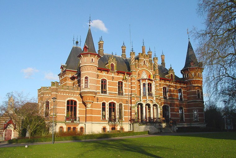
Photo: Wikimedia, CC BY-SA 3.0.
Hoeilaart is a municipality in the province of Flemish Brabant, Belgium. The name Hoeilaart is of Gallic-Celtic origin, coming from "Ho-Lar," meaning a high clearing in the woods. Hoeilaart is situated 4 km north of École communale Les Colibris.
École communale Les Colibris
- Type: School
- Category: education
- Location: La Hulpe, Arrondissement of Nivelles, Walloon Brabant, Wallonia, Belgium, Benelux, Europe
- View on OpenStreetMap
Latitude
50.73103° or 50° 43′ 52″ northLongitude
4.48511° or 4° 29′ 6″ eastOpen location code
9F26PFJP+C2OpenStreetMap ID
way 541717070OpenStreetMap feature
amenity=school
This page is based on OpenStreetMap, Wikidata, and Wikimedia Commons.
We’d love your help improving our open data sources. Thank you for contributing.
Satellite Map
Discover École communale Les Colibris from above in high-definition satellite imagery.
Notable Places Nearby
Highlights include Square des Trois Colonnes and Bibliothèque communale Will.
Nearby Places
Explore places such as Art-Wood and La Hulpe Eugène Castaigne.
Walloon Brabant: Must-Visit Destinations
Delve into Waterloo, Villers-la-Ville, and Louvain-la-Neuve.
Curious Schools to Discover
Uncover intriguing schools from every corner of the globe.
About Mapcarta. Data © OpenStreetMap contributors and available under the Open Database License". Text is available under the CC BY-SA 4.0 license, except for photos, directions, and the map. Photo: Myrabella, CC BY-SA 3.0.