Mare Dobis
Mare Dobis is a settling basin in Coconino County, Arizona. Mare Dobis is situated nearby to the settling basin No. 1 Secondary Clarifier, as well as near No. 2 Secondary Clarifier.| Tap on a place to explore it |
Places of Interest Nearby
Highlights include Lowell Observatory and J Lawrence Walkup Skydome.
Lowell Observatory

Photo: Pretzelpaws, CC BY-SA 3.0.
Lowell Observatory is an astronomical observatory in Flagstaff, Arizona, United States. Lowell Observatory was established in 1894, placing it among the oldest observatories in the United States, and was designated a National Historic Landmark in 1965. Lowell Observatory is situated 2½ miles northwest of Mare Dobis.
J Lawrence Walkup Skydome
Stadium

Photo: Derek.cashman, CC BY-SA 3.0.
The J. Lawrence Walkup Skydome is an indoor multipurpose stadium in the southwestern United States, located on the campus of Northern Arizona University in Flagstaff, Arizona. J Lawrence Walkup Skydome is situated 1¼ miles west of Mare Dobis.
Orpheum Theater
Theater building
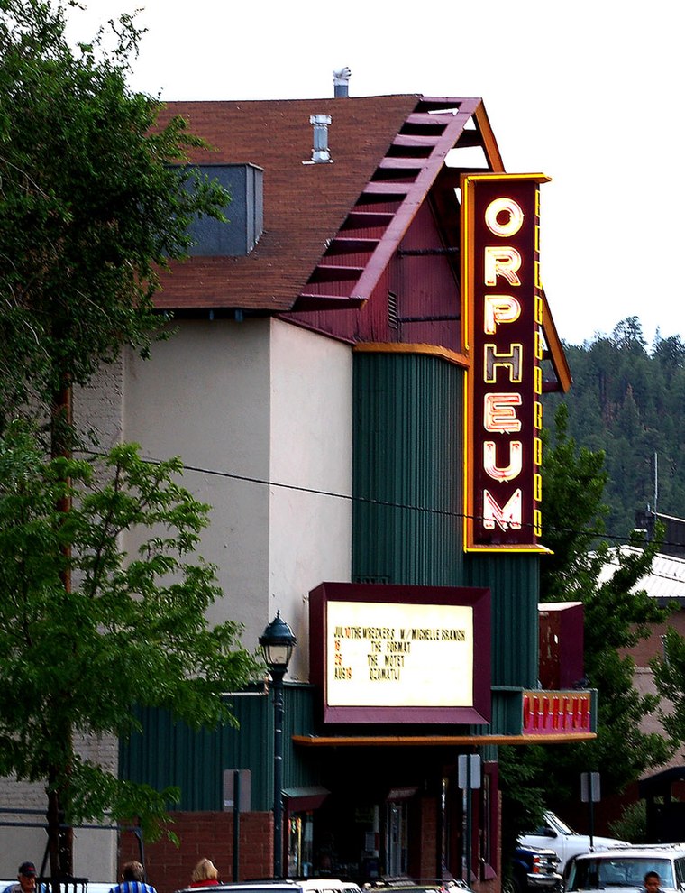
Photo: Derek.cashman, CC BY-SA 3.0.
The Orpheum Theater is an old movie house in Flagstaff, Arizona, originally named the Majestic Opera House. The building was constructed in 1911. It was rebuilt and expanded in 1917, and renamed the Orpheum. Orpheum Theater is situated 1½ miles northwest of Mare Dobis.
Places in the Area
Nearby places include Flagstaff and Fort Tuthill.
Flagstaff

Photo: StellarD, CC BY-SA 4.0.
Flagstaff is a city of over 75,000 people near the San Francisco Peaks mountain range of northern Arizona and the Grand Canyon. At an altitude of 6,990 ft, Flagstaff and much of the surrounding region are substantially cooler than the low desert that dominates the southern part of the state.
Fort Tuthill
Locality
Fort Tuthill is a former National Guard training facility and a county park situated in Coconino County, Arizona. It has an estimated elevation of 6,995 feet above sea level. The fort is listed on the National Register of Historic Places. Fort Tuthill is situated 4½ miles southwest of Mare Dobis.
Elden Pueblo
Locality

Photo: Ken Lund, CC BY-SA 2.0.
Elden Pueblo was a prehistoric Native American village at the foot of Mount Elden near Flagstaff, Arizona. The pueblo is considered part of a major trading system. Elden Pueblo is situated 5 miles northeast of Mare Dobis.
Mare Dobis
- Type: Settling basin
- Category: body of water
- Location: Coconino County, Arizona, Southwest, United States, North America
- View on OpenStreetMap
Latitude
35.18361° or 35° 11′ 1″ northLongitude
-111.63124° or 111° 37′ 53″ westOpen location code
857C59M9+CGOpenStreetMap ID
way 547175770OpenStreetMap feature
natural=waterOpenStreetMap feature
water=wastewater
This page is based on OpenStreetMap, Wikidata, and Wikimedia Commons.
We’d love your help improving our open data sources. Thank you for contributing.
Satellite Map
Discover Mare Dobis from above in high-definition satellite imagery.
Notable Places Nearby
Highlights include No. 1 Secondary Clarifier and No. 2 Secondary Clarifier.
Nearby Places
Explore places such as Influent Pump Station and Flagstaff Urban Trail System.
Arizona: Must-Visit Destinations
Delve into Phoenix, Tucson, Mesa, and Flagstaff.
Curious Settling Basins to Discover
Uncover intriguing settling basins from every corner of the globe.
About Mapcarta. Data © OpenStreetMap contributors and available under the Open Database License". Text is available under the CC BY-SA 4.0 license, except for photos, directions, and the map. Photo: Tobi 87, CC BY-SA 3.0.