SPA - Refuge Saint-Roch
SPA - Refuge Saint-Roch is an animal shelter in Fontvieille, Arrondissement of Arles, Provence-Alpes-Côte d’Azur which is located on D27. SPA - Refuge Saint-Roch is situated nearby to the peak Mont Paon, as well as near the forest Le Vallon des Marrettes.| Tap on a place to explore it |
- Type: Animal shelter
- Also known as: “Société protectrice des animaux”
- Address: D27, Les Baux-de-Provence, 13520
Places of Interest Nearby
Highlights include Château des Baux and Castrum de Montpaon.
Château des Baux
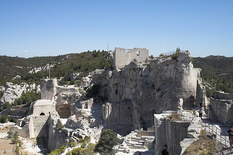
Photo: Ignis, CC BY-SA 3.0.
The Château des Baux is a ruined fortified castle built during the 10th century, located in Les Baux-de-Provence, Bouches-du-Rhône, southern France. Château des Baux is situated 2 km east of SPA - Refuge Saint-Roch.
Castrum de Montpaon
Archaeological site

Photo: Malost, CC BY-SA 3.0.
Castrum de Montpaon is an archaeological site, which is situated 1¼ km west of SPA - Refuge Saint-Roch.
Val d’Enfer
Val d'Enfer, is a valley cut into the rock by water erosion. It is located near the village of Les Baux-de-Provence in Provence south eastern France and it takes its name from the strangeness of its white limestone rock formations. Val d’Enfer is situated 2 km northeast of SPA - Refuge Saint-Roch.Places in the Area
Nearby places include Les Baux-de-Provence and Maussane-les-Alpilles.
Les Baux-de-Provence

Photo: Benh, CC BY-SA 3.0.
Les Baux de Provence is a beautiful medieval town in Provence, whose hillsides are brushed with lavender.
Maussane-les-Alpilles
Village

Photo: Gortyna, CC BY-SA 3.0.
Maussane-les-Alpilles is a commune in the Bouches-du-Rhône department in the Provence-Alpes-Cote d'Azur region in Southern France. Part of Alpilles Regional Natural Park, it is located between Saint-Rémy-de-Provence to the north and Saint-Martin-de-Crau to the south. Maussane-les-Alpilles is situated 3½ km southeast of SPA - Refuge Saint-Roch.
Tours de Castillon
Locality

Photo: Malost, CC BY-SA 3.0.
Tours de Castillon is a locality, which is situated 4½ km south of SPA - Refuge Saint-Roch.
SPA - Refuge Saint-Roch
- Category: building
- Location: Fontvieille, Arrondissement of Arles, Bouches-du-Rhône, Provence-Alpes-Côte d’Azur, France, Europe
- View on OpenStreetMap
Latitude
43.74177° or 43° 44′ 30″ northLongitude
4.77239° or 4° 46′ 21″ eastOpen location code
8FM6PQRC+PXOpenStreetMap ID
way 551679693OpenStreetMap feature
amenity=animal_shelterOpenStreetMap feature
building=no
This page is based on OpenStreetMap, Wikidata, and Wikimedia Commons.
We’d love your help improving our open data sources. Thank you for contributing.
Satellite Map
Discover SPA - Refuge Saint-Roch from above in high-definition satellite imagery.
Notable Places Nearby
Highlights include Mont Paon and La citerne.
Nearby Places
Explore places such as Reservoir les Canonnetes and Domaine départemental du Mont Paon.
Bouches-du-Rhône: Must-Visit Destinations
Delve into Marseille, Aix-en-Provence, Arles, and Salon-de-Provence.
Curious Animal Shelters to Discover
Uncover intriguing animal shelters from every corner of the globe.
About Mapcarta. Data © OpenStreetMap contributors and available under the Open Database License". Text is available under the CC BY-SA 4.0 license, except for photos, directions, and the map. Photo: Nikater, CC BY-SA 4.0.