Reading Riverside
Reading Riverside is a residential area in Reading, England. Reading Riverside is situated nearby to the park Holy Brook Nook, as well as near Katesgrove Primary School.| Tap on a place to explore it |
Places of Interest Nearby
Highlights include County Lock and Reading Railway Station.
County Lock
River

Photo: Bill Nicholls, CC BY-SA 2.0.
County Lock is a lock on the River Kennet in Reading town centre in the English county of Berkshire. It is now administered by the Canal & River Trust as part of the Kennet and Avon Canal.
Reading Railway Station
Railway station
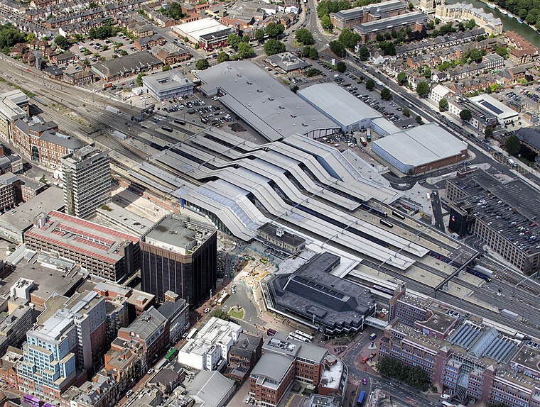
Photo: John Fielding, CC BY 2.0.
Reading railway station is a major transport hub in the town of Reading in Berkshire, England, it is 36 miles west of London Paddington. It is sited on the northern edge of the town centre, near to the main retail and commercial areas and the River Thames. Reading Railway Station is situated 1 mile north of Reading Riverside.
Reading Abbey

Photo: Chris j wood, CC BY-SA 4.0.
Reading Abbey is a large, ruined abbey in the centre of the town of Reading, in the English county of Berkshire. It was founded by Henry I in 1121 "for the salvation of my soul, and the souls of King William, my father, and of King William, my brother, and Queen Maud, my wife, and all my ancestors and successors." In its heyday the abbey was one of Europe's largest royal monasteries. Reading Abbey is situated 3,800 feet northeast of Reading Riverside.
Places in the Area
Nearby places include Coley and Coley Park.
Coley
Suburb

Photo: Uli Harder, CC BY-SA 2.0.
Coley is an inner-town district near the centre of the town of Reading, in the English county of Berkshire. It is often referred to as Old Coley, to distinguish it from the adjacent, and much more recent, suburb of Coley Park.
Coley Park
Suburb

Photo: Graham Horn, CC BY-SA 2.0.
Coley Park is a suburban village to the south of the town of Reading in the English county of Berkshire. It is largely built on the country estate of the same name, surrounding Coley House.
Whitley
Suburb

Photo: Andrew Smith, CC BY-SA 2.0.
Whitley is a suburb of the town of Reading, Berkshire, England. It is also an electoral ward of the Borough of Reading.
Reading Riverside
- Type: Residential area
- Address: Reading, RG1 6EL
- Location: Reading, England, United Kingdom, Britain and Ireland, Europe
- View on OpenStreetMap
Latitude
51.44744° or 51° 26′ 51″ northLongitude
-0.97407° or 0° 58′ 27″ westOperator
Weston Homes PLCOpen location code
9C3XC2WG+X9OpenStreetMap ID
way 611884301OpenStreetMap feature
landuse=residential
This page is based on OpenStreetMap, Wikidata, and Wikimedia Commons.
We’d love your help improving our open data sources. Thank you for contributing.
Satellite Map
Discover Reading Riverside from above in high-definition satellite imagery.
Notable Places Nearby
Highlights include Holy Brook Nook and Katesgrove Primary School.
Nearby Places
Explore places such as Lok’n Store and Katesgrove Lane.
England: Must-Visit Destinations
Delve into London, Manchester, Sheffield, and Leeds.
Curious Residential Areas to Discover
Uncover intriguing residential areas from every corner of the globe.
About Mapcarta. Data © OpenStreetMap contributors and available under the Open Database License". Text is available under the CC BY-SA 4.0 license, except for photos, directions, and the map. Photo: Wikimedia, CC BY-SA 2.0.