Feld A
Feld A is a cemetery in Karlsruhe, Rhine-Neckar, Baden-Württemberg. Feld A is situated nearby to the cemetery Feld B, as well as near Feld 5.| Tap on a place to explore it |
Places of Interest Nearby
Highlights include St. Cyriakus and Karlsruhe-Oberreut Badeniaplatz.

Karlsruhe-Oberreut Badeniaplatz
Railway stop
 Karlsruhe-Oberreut Badeniaplatz is a railway stop, which is situated 450 metres southwest of Feld A.
Europahalle
Stadium
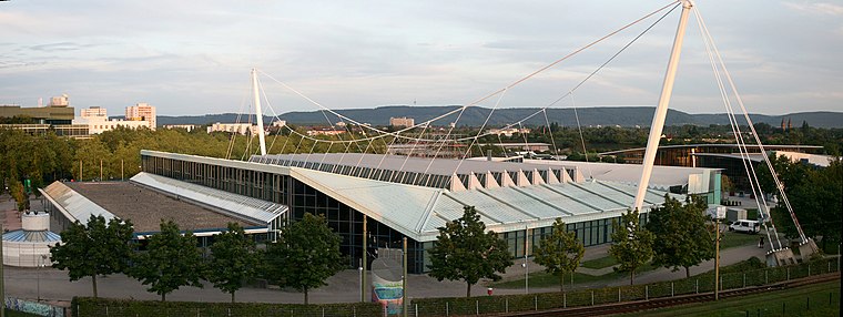
Photo: Bough, CC BY-SA 2.0 de.
Europahalle is an indoor sporting arena located in Karlsruhe, Germany. The capacity of the arena is 9,000 people. The venue has featured a number of world record performances in athletics, including a jump of 2.07 m in the high jump by Heike Henkel in 1992, when the Europahalle hosted the German Indoor Championships. Europahalle is situated 1½ km north of Feld A.
Places in the Area
Nearby places include Mühlburg and Rheinstetten.
Mühlburg
Suburb

Photo: Baden-Paul, CC0.
Mühlburg is a district of Karlsruhe, Germany. The district is further divided into Alt-Mühlburg, Weingärtensiedlung, Rheinhafen and Mühlburger Feld. Mühlburg is situated 3½ km north of Feld A.
Rheinstetten
Town

Photo: DALIBRI, CC BY-SA 4.0.
Rheinstetten is a town in the west of Baden-Württemberg on the border to Rhineland-Palatinate. It is situated to the south-west of Karlsruhe and belongs to the rural district of Karlsruhe. Rheinstetten is situated 5 km west of Feld A.
Ettlingen

Photo: Martin-D, CC BY-SA 2.5.
Ettlingen, tucked between Karlsruhe and the Black Forest, is a small city with a history dating back to the Roman Empire.
Feld A
- Type: Cemetery
- Category: burial
- Location: Karlsruhe, Karlsruhe Region, Rhine-Neckar, Baden-Württemberg, Germany, Central Europe, Europe
- View on OpenStreetMap
Latitude
48.9841° or 48° 59′ 3″ northLongitude
8.37353° or 8° 22′ 25″ eastOpen location code
8FWCX9MF+JCOpenStreetMap ID
way 61681812OpenStreetMap feature
landuse=cemetery
This page is based on OpenStreetMap, Wikidata, and Wikimedia Commons.
We’d love your help improving our open data sources. Thank you for contributing.
Satellite Map
Discover Feld A from above in high-definition satellite imagery.
Places with the Same Name
Discover other places named “Feld A”.
Notable Places Nearby
Highlights include Feld B and Feld 5.
Nearby Places
Explore places such as Tor des Lebens and Bulach Friedhof.
Rhine-Neckar: Must-Visit Destinations
Delve into Heidelberg, Mannheim, Heilbronn, and Sinsheim.
Curious Cemeteries to Discover
Uncover intriguing cemeteries from every corner of the globe.
About Mapcarta. Data © OpenStreetMap contributors and available under the Open Database License". Text is available under the CC BY-SA 4.0 license, except for photos, directions, and the map. Photo: Ruhrfisch, CC BY-SA 3.0.