Grottington Cottages
Grottington Cottages is a residential area in Corbridge, Northumberland, England. Grottington Cottages is situated nearby to the village Great Whittington, as well as near the hamlet Halton.| Tap on a place to explore it |
Places of Interest Nearby
Highlights include Milecastle 23 and Milecastle 22.
Milecastle 23
Archaeological site

Photo: Sam.roebuck, CC BY 3.0.
Milecastle 23 was a milecastle of the Roman Hadrian's Wall. Its remains exist as a low, grass covered platform with traces of an external ditch. It is located to the south of the B6318 Military Road around 1.5 kilometres west of its junction with the A68. Milecastle 23 is situated 4,100 feet southwest of Grottington Cottages.
Milecastle 22
Archaeological site

Photo: Mike Quinn, CC BY-SA 2.0.
Milecastle 22 was a milecastle of the Roman Hadrian's Wall. Its remains exist as a low, turf covered platform just east of the Portgate roundabout. The platform is 0.5 metres on the east side, reducing to only a parch mark on the west side. Milecastle 22 is situated 1 mile southeast of Grottington Cottages.
Aydon Castle
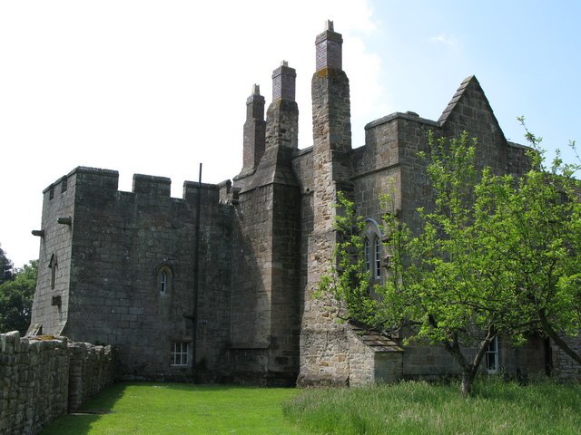
Photo: Wikimedia, CC BY-SA 2.0.
Aydon Castle, previously sometimes called Aydon Hall, is a fortified manor house at Aydon near to the town of Corbridge, Northumberland, England. It is a Scheduled Ancient Monument, and is designated by English Heritage as a Grade I listed building. Aydon Castle is situated 2½ miles southeast of Grottington Cottages.
Places in the Area
Nearby places include Great Whittington and Halton.
Great Whittington
Village

Photo: Oliver Dixon, CC BY-SA 2.0.
Great Whittington is a village and former civil parish, now in the parish of Whittington, in Northumberland, England, 7 miles NE of Hexham. In 1951 the parish had a population of 158, in 2011 it had a population of 401.
Halton
Hamlet

Photo: Mike Quinn, CC BY-SA 2.0.
Halton is a village and former civil parish, now in the parish of Whittington, in the southern part of Northumberland, England. It is situated 3 miles north of Corbridge just south of Hadrian's Wall. Halton is situated 1½ miles southeast of Grottington Cottages.
Bingfield
Hamlet

Photo: Oliver Dixon, CC BY-SA 2.0.
Bingfield is a village and former civil parish, now in the parish of Whittington, in Northumberland, in England. It is situated to the north of Corbridge, off the A68 road and includes some properties situated on the A68. Bingfield is situated 1½ miles north of Grottington Cottages.
Grottington Cottages
Latitude
55.02305° or 55° 1′ 23″ northLongitude
-2.0266° or 2° 1′ 36″ westOpen location code
9C7V2XFF+69OpenStreetMap ID
way 619471947OpenStreetMap feature
landuse=residential
This page is based on OpenStreetMap, Wikidata, and Wikimedia Commons.
We’d love your help improving our open data sources. Thank you for contributing.
Satellite Map
Discover Grottington Cottages from above in high-definition satellite imagery.
Notable Places Nearby
Highlights include High Balk and Great Whittington Village Hall.
Nearby Places
Explore places such as Little Whittington and Grottington Farm.
Northumberland: Must-Visit Destinations
Delve into Berwick-upon-Tweed, Lindisfarne, Alnwick, and Morpeth.
Curious Residential Areas to Discover
Uncover intriguing residential areas from every corner of the globe.
About Mapcarta. Data © OpenStreetMap contributors and available under the Open Database License". Text is available under the CC BY-SA 4.0 license, except for photos, directions, and the map. Photo: RHaworth, CC BY 2.5.